
Topografische Karte Bompensiere
Interaktive Karte
Klicken Sie auf die Karte, um die Höhe anzuzeigen.
Über diese Karte
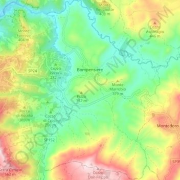
Name: Topografische Karte Bompensiere, Höhe, Relief.
Ort: Bompensiere, Caltanissetta, Sicily, 93010, Italy (37.43393 13.75927 37.49893 13.81269)
Durchschnittliche Höhe: 319 m
Minimale Höhe: 154 m
Maximale Höhe: 583 m
The town is arranged along a single main street on whose sides the houses are divided, almost uniformly distributed. The lowest point of the town is to the north-west, at an altitude of about 270 meters above sea level (Piana Giarre); the highest point is located in the south-east at an altitude of about 320 meters above sea level (Contrada Portella).
Andere topografische Karten
Klicken Sie auf eine Karte, um ihre Topografie, ihre Höhe und ihr Relief anzuzeigen.
Mussomeli
Italy > Sicily > Caltanissetta
Mussomeli, Caltanissetta, Sicily, 93014, Italy
Durchschnittliche Höhe: 420 m
Caltanissetta
Italy > Sicily > Caltanissetta
Caltanissetta, Sicily, 93100, Italy
Durchschnittliche Höhe: 428 m