
Topografische Karte Paintsville Lake State Park
Interaktive Karte
Klicken Sie auf die Karte, um die Höhe anzuzeigen.
Über diese Karte
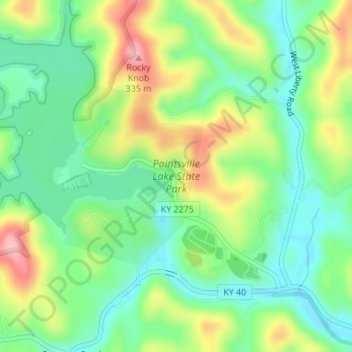
Name: Topografische Karte Paintsville Lake State Park, Höhe, Relief.
Durchschnittliche Höhe: 241 m
Minimale Höhe: 184 m
Maximale Höhe: 336 m
Andere topografische Karten
Klicken Sie auf eine Karte, um ihre Topografie, ihre Höhe und ihr Relief anzuzeigen.
Paintsville
United States > Kentucky > Johnson County
Paintsville, Johnson County, Kentucky, 41240, United States
Durchschnittliche Höhe: 243 m
Paintsville
United States > Kentucky > Johnson County > Paintsville > Paintsville
Paintsville, Johnson County, Kentucky, 41240, United States
Durchschnittliche Höhe: 243 m
Sitka
United States > Kentucky > Johnson County
Sitka, Johnson County, Kentucky, 41255, United States
Durchschnittliche Höhe: 274 m
Volga
United States > Kentucky > Johnson County > Volga
Volga, Johnson County, Kentucky, 41255, United States
Durchschnittliche Höhe: 267 m
Staffordsville
United States > Kentucky > Johnson County
Staffordsville, Johnson County, Kentucky, 41256, United States
Durchschnittliche Höhe: 238 m
Paintsville Lake
United States > Kentucky > Johnson County
Paintsville Lake, Johnson County, Kentucky, United States
Durchschnittliche Höhe: 285 m
Dawkins
United States > Kentucky > Johnson County
Dawkins, Johnson County, Kentucky, 41268, United States
Durchschnittliche Höhe: 238 m
West Van Lear
United States > Kentucky > Johnson County
West Van Lear, Johnson County, Kentucky, 41268, United States
Durchschnittliche Höhe: 242 m