
Topografische Karte Ashland
Interaktive Karte
Klicken Sie auf die Karte, um die Höhe anzuzeigen.
Über diese Karte
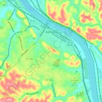
Name: Topografische Karte Ashland, Höhe, Relief.
Ort: Ashland, Boyd County, Kentucky, 41101, United States (38.43440 -82.68193 38.49846 -82.60629)
Durchschnittliche Höhe: 196 m
Minimale Höhe: 155 m
Maximale Höhe: 270 m
Andere topografische Karten
Klicken Sie auf eine Karte, um ihre Topografie, ihre Höhe und ihr Relief anzuzeigen.
Ironville
United States > Kentucky > Boyd County
Ironville, Boyd County, Kentucky, 41102, United States
Durchschnittliche Höhe: 214 m
Westwood
United States > Kentucky > Boyd County > Fairview
Westwood, Fairview, Boyd County, Kentucky, United States
Durchschnittliche Höhe: 192 m
Cannonsburg
United States > Kentucky > Boyd County
Cannonsburg, Boyd County, Kentucky, 41105, United States
Durchschnittliche Höhe: 217 m
Boltsfork
United States > Kentucky > Boyd County > Boltsfork
Boltsfork, Boyd County, Kentucky, United States
Durchschnittliche Höhe: 241 m
Catlettsburg
United States > Kentucky > Boyd County
Catlettsburg, Boyd County, Kentucky, United States
Durchschnittliche Höhe: 190 m
Rush
United States > Kentucky > Boyd County
Rush, Boyd County, Kentucky, 41168, United States
Durchschnittliche Höhe: 244 m