
Spenden
Rüste dich für dein nächstes Abenteuer:
Als Amazon-Partner verdient diese Seite an qualifizierten Käufen, ohne dass Ihnen zusätzliche Kosten entstehen.
Topografische Karte Table Bluff
Klicken Sie auf die Karte, um die Höhe anzuzeigen.
Spenden
Rüste dich für dein nächstes Abenteuer:
Als Amazon-Partner verdient diese Seite an qualifizierten Käufen, ohne dass Ihnen zusätzliche Kosten entstehen.
Über diese Karte
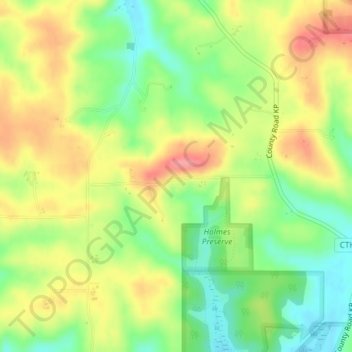
Name: Topografische Karte Table Bluff, Höhe, Relief.
Durchschnittliche Höhe: 306 m
Minimale Höhe: 262 m
Maximale Höhe: 353 m
Spenden
Rüste dich für dein nächstes Abenteuer:
Als Amazon-Partner verdient diese Seite an qualifizierten Käufen, ohne dass Ihnen zusätzliche Kosten entstehen.
Andere topografische Karten
Klicken Sie auf eine Karte, um ihre Topografie, ihre Höhe und ihr Relief anzuzeigen.
Madison
United States > Wisconsin > Dane County
The city is sometimes described as The City of Four Lakes, comprising the four successive lakes of the Yahara River: Lake Mendota ("Fourth Lake"), Lake Monona ("Third Lake"), Lake Waubesa ("Second Lake") and Lake Kegonsa ("First Lake"), although Waubesa and Kegonsa are not actually in Madison, but just south…
Durchschnittliche Höhe: 284 m
Spenden
Rüste dich für dein nächstes Abenteuer:
Als Amazon-Partner verdient diese Seite an qualifizierten Käufen, ohne dass Ihnen zusätzliche Kosten entstehen.
Mount Horeb
United States > Wisconsin > Dane County
Located in Southwest Wisconsin, Mount Horeb is situated in a region referred to as the Driftless Area. While including parts of eastern Minnesota, northeastern Iowa, and northwest Illinois, the Driftless Area is widely regarded as a distinct feature to the Wisconsin landscape, stretching across eighteen…
Durchschnittliche Höhe: 357 m
Spring Harbor
United States > Wisconsin > Dane County > Madison > Mendota Beach
Durchschnittliche Höhe: 279 m
Spenden
Rüste dich für dein nächstes Abenteuer:
Als Amazon-Partner verdient diese Seite an qualifizierten Käufen, ohne dass Ihnen zusätzliche Kosten entstehen.
Spenden
Rüste dich für dein nächstes Abenteuer:
Als Amazon-Partner verdient diese Seite an qualifizierten Käufen, ohne dass Ihnen zusätzliche Kosten entstehen.
Spenden
Rüste dich für dein nächstes Abenteuer:
Als Amazon-Partner verdient diese Seite an qualifizierten Käufen, ohne dass Ihnen zusätzliche Kosten entstehen.
Spenden
Rüste dich für dein nächstes Abenteuer:
Als Amazon-Partner verdient diese Seite an qualifizierten Käufen, ohne dass Ihnen zusätzliche Kosten entstehen.
Sun Prairie
United States > Wisconsin > Dane County
The landscape of the city consists mostly of gently rolling hills and plains. The elevation of the city averages about 984 feet (300 m) above mean sea level.
Durchschnittliche Höhe: 293 m
Spenden
Rüste dich für dein nächstes Abenteuer:
Als Amazon-Partner verdient diese Seite an qualifizierten Käufen, ohne dass Ihnen zusätzliche Kosten entstehen.
Spenden
Rüste dich für dein nächstes Abenteuer:
Als Amazon-Partner verdient diese Seite an qualifizierten Käufen, ohne dass Ihnen zusätzliche Kosten entstehen.
Mazomanie Bottoms State Natural Area
United States > Wisconsin > Dane County
Durchschnittliche Höhe: 228 m
Spenden
Rüste dich für dein nächstes Abenteuer:
Als Amazon-Partner verdient diese Seite an qualifizierten Käufen, ohne dass Ihnen zusätzliche Kosten entstehen.
Sun Prairie
United States > Wisconsin > Dane County
The landscape of the city consists mostly of gently rolling hills and plains. The elevation of the city averages about 984 feet (300 m) above mean sea level.
Durchschnittliche Höhe: 293 m
Goose Lake Wildlife Area
United States > Wisconsin > Dane County > Town of Deerfield
Durchschnittliche Höhe: 267 m
Mount Horeb
United States > Wisconsin > Dane County
Located in southwestern Wisconsin, Mount Horeb is situated in a region referred to as the Driftless Area. While including parts of southeastern Minnesota, northeastern Iowa, and northwestern Illinois, the Driftless Area is a distinct feature of the Wisconsin landscape, stretching across eighteen different…
Durchschnittliche Höhe: 357 m
Spenden
Rüste dich für dein nächstes Abenteuer:
Als Amazon-Partner verdient diese Seite an qualifizierten Käufen, ohne dass Ihnen zusätzliche Kosten entstehen.
Madison
United States > Wisconsin > Dane County
According to the United States Census Bureau, the city has an area of 94.03 square miles (243.54 km2), of which 76.79 square miles (198.89 km2) is land and 17.24 square miles (44.65 km2) is water. The city's lowest elevation is the intersection of Regas Road and Corporate Drive on the east side, at 836.9 ft…
Durchschnittliche Höhe: 284 m
Spenden
Rüste dich für dein nächstes Abenteuer:
Als Amazon-Partner verdient diese Seite an qualifizierten Käufen, ohne dass Ihnen zusätzliche Kosten entstehen.
Madison
United States > Wisconsin > Dane County
According to the United States Census Bureau, the city has a total area of 94.03 square miles (243.54 km2), of which 76.79 square miles (198.89 km2) is land and 17.24 square miles (44.65 km2) is water. The city's lowest elevation is the intersection of Regas Road and Corporate Drive on the east side, at 836.9…
Durchschnittliche Höhe: 284 m
Madison
United States > Wisconsin > Dane County
According to the United States Census Bureau, the city has an area of 94.03 square miles (243.54 km2), of which 76.79 square miles (198.89 km2) is land and 17.24 square miles (44.65 km2) is water. The city's lowest elevation is the intersection of Regas Road and Corporate Drive on the east side, at 836.9 ft…
Durchschnittliche Höhe: 284 m
Spenden
Rüste dich für dein nächstes Abenteuer:
Als Amazon-Partner verdient diese Seite an qualifizierten Käufen, ohne dass Ihnen zusätzliche Kosten entstehen.
Spenden
Rüste dich für dein nächstes Abenteuer:
Als Amazon-Partner verdient diese Seite an qualifizierten Käufen, ohne dass Ihnen zusätzliche Kosten entstehen.
Spenden
Rüste dich für dein nächstes Abenteuer:
Als Amazon-Partner verdient diese Seite an qualifizierten Käufen, ohne dass Ihnen zusätzliche Kosten entstehen.
Walking Iron County Park
United States > Wisconsin > Dane County > Town of Mazomanie
Durchschnittliche Höhe: 236 m
Deansville Wildlife Area
United States > Wisconsin > Dane County > Town of York
Durchschnittliche Höhe: 264 m
Spenden
Rüste dich für dein nächstes Abenteuer:
Als Amazon-Partner verdient diese Seite an qualifizierten Käufen, ohne dass Ihnen zusätzliche Kosten entstehen.
Madison
United States > Wisconsin > Dane County
According to the United States Census Bureau, the city has a total area of 94.03 square miles (243.54 km2), of which 76.79 square miles (198.89 km2) is land and 17.24 square miles (44.65 km2) is water. The city's lowest elevation is the intersection of Regas Road and Corporate Drive on the east side, at 836.9…
Durchschnittliche Höhe: 284 m
Spenden
Rüste dich für dein nächstes Abenteuer:
Als Amazon-Partner verdient diese Seite an qualifizierten Käufen, ohne dass Ihnen zusätzliche Kosten entstehen.
Isthmus Path Prairie Garden
United States > Wisconsin > Dane County > Madison
Durchschnittliche Höhe: 262 m
Spenden
Rüste dich für dein nächstes Abenteuer:
Als Amazon-Partner verdient diese Seite an qualifizierten Käufen, ohne dass Ihnen zusätzliche Kosten entstehen.
Madison
United States > Wisconsin > Dane County
According to the United States Census Bureau, the city has a total area of 94.03 square miles (243.54 km2), of which 76.79 square miles (198.89 km2) is land and 17.24 square miles (44.65 km2) is water. The city's lowest elevation is the intersection of Regas Road and Corporate Drive on the east side, at 836.9…
Durchschnittliche Höhe: 284 m
Spenden
Rüste dich für dein nächstes Abenteuer:
Als Amazon-Partner verdient diese Seite an qualifizierten Käufen, ohne dass Ihnen zusätzliche Kosten entstehen.
Spenden
Rüste dich für dein nächstes Abenteuer:
Als Amazon-Partner verdient diese Seite an qualifizierten Käufen, ohne dass Ihnen zusätzliche Kosten entstehen.
Spenden
Rüste dich für dein nächstes Abenteuer:
Als Amazon-Partner verdient diese Seite an qualifizierten Käufen, ohne dass Ihnen zusätzliche Kosten entstehen.