
Topografische Karte Stockinbingal
Interaktive Karte
Klicken Sie auf die Karte, um die Höhe anzuzeigen.
Über diese Karte
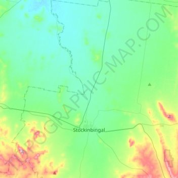
Name: Topografische Karte Stockinbingal, Höhe, Relief.
Durchschnittliche Höhe: 316 m
Minimale Höhe: 256 m
Maximale Höhe: 528 m
Andere topografische Karten
Klicken Sie auf eine Karte, um ihre Topografie, ihre Höhe und ihr Relief anzuzeigen.
Gundagai
Australia > New South Wales > Cootamundra-Gundagai Regional Council > Gundagai
Gundagai, Cootamundra-Gundagai Regional Council, New South Wales, 2722, Australia
Durchschnittliche Höhe: 309 m
Cootamundra
Australia > New South Wales > Cootamundra-Gundagai Regional Council
Cootamundra, Cootamundra-Gundagai Regional Council, New South Wales, 2590, Australia
Durchschnittliche Höhe: 407 m