
Topografische Karte Aurora
Interaktive Karte
Klicken Sie auf die Karte, um die Höhe anzuzeigen.
Aurora
Aurora's official elevation, posted on signs at the city limits, is 5,471 feet (1,668 m). However, the city spans a difference in elevation of nearly 1,000 feet (300 m). The lowest elevation of 5,285 feet (1,611 m) is found at the point where Sand Creek crosses the city limit in the northwest corner of the city, while the highest elevation of 6,229 feet (1,899 m) is on the extreme southern border of the city in Douglas County, near the intersection of Inspiration and Gartrell roads.[20]
Über diese Karte
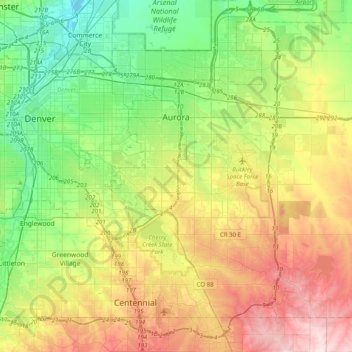
Name: Topografische Karte Aurora, Höhe, Relief.
Ort: Aurora, Adams County, Colorado, United States (39.55106 -104.88654 39.82697 -104.48891)
Durchschnittliche Höhe: 1’691 m
Minimale Höhe: 1’548 m
Maximale Höhe: 1’930 m