
Spenden
Rüste dich für dein nächstes Abenteuer:
Als Amazon-Partner verdient diese Seite an qualifizierten Käufen, ohne dass Ihnen zusätzliche Kosten entstehen.
Topografische Karte Granger
Klicken Sie auf die Karte, um die Höhe anzuzeigen.
Spenden
Rüste dich für dein nächstes Abenteuer:
Als Amazon-Partner verdient diese Seite an qualifizierten Käufen, ohne dass Ihnen zusätzliche Kosten entstehen.
Über diese Karte
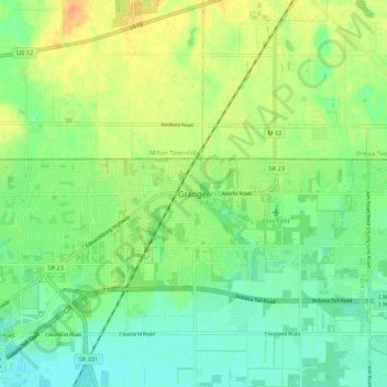
Name: Topografische Karte Granger, Höhe, Relief.
Ort: Granger, Saint Joseph County, Indiana, 46530, United States (41.71338 -86.15084 41.79338 -86.07084)
Durchschnittliche Höhe: 244 m
Minimale Höhe: 228 m
Maximale Höhe: 266 m
Spenden
Rüste dich für dein nächstes Abenteuer:
Als Amazon-Partner verdient diese Seite an qualifizierten Käufen, ohne dass Ihnen zusätzliche Kosten entstehen.
Andere topografische Karten
Klicken Sie auf eine Karte, um ihre Topografie, ihre Höhe und ihr Relief anzuzeigen.
South Bend
United States > Indiana > Saint Joseph County
On September 29, 1929, South Bend completed its "track elevation program". This was a railroad infrastructure project which saw the removal of Grand Trunk Western Railroad tracks from Division Street, the removal of level crossings from Chapin to Miami streets, the creation of a modern freight layout, and the…
Durchschnittliche Höhe: 236 m
Spenden
Rüste dich für dein nächstes Abenteuer:
Als Amazon-Partner verdient diese Seite an qualifizierten Käufen, ohne dass Ihnen zusätzliche Kosten entstehen.
South Bend
United States > Indiana > Saint Joseph County
On September 29, 1929, South Bend completed its "track elevation program". This was a railroad infrastructure project which saw the removal of Grand Trunk Western Railroad tracks from Division Street, the removal of level crossings from Chapin to Miami streets, the creation of a modern freight layout, and the…
Durchschnittliche Höhe: 236 m
Spenden
Rüste dich für dein nächstes Abenteuer:
Als Amazon-Partner verdient diese Seite an qualifizierten Käufen, ohne dass Ihnen zusätzliche Kosten entstehen.
South Bend
United States > Indiana > Saint Joseph County
On September 29, 1929, South Bend completed its "track elevation program". This was a railroad infrastructure project which saw the removal of Grand Trunk Western Railroad tracks from Division Street, the removal of level crossings from Chapin to Miami streets, the creation of a modern freight layout, and the…
Durchschnittliche Höhe: 236 m
Spenden
Rüste dich für dein nächstes Abenteuer:
Als Amazon-Partner verdient diese Seite an qualifizierten Käufen, ohne dass Ihnen zusätzliche Kosten entstehen.