

Topografische Karte Inman Valley
Klicken Sie auf die Karte, um die Höhe anzuzeigen.
Inman Valley
In the valley is Selwyn Rock (35°29′47″S 138°30′45″E / 35.4965°S 138.5124°E / -35.4965; 138.5124) a glaciated pavement in the bed of the Inman River. It was first described in 1859 by, and later named for, A.R.C. Selwyn, who was Victorian Government geologist at the time. Glacial grooves and striations on the polished surface indicate glacial movement to the north-west. Boulder clays, tillites and erratics are also common in the area, which underwent glaciation during the Permian (approximately 270 Ma). The pavement of Cambrian bedrock and Permian glacial sediments were exposed during the Tertiary when the Inman River eroded the topography to its present-day surface. A cafe overlooks the glaciated bed of the river, with access onto the rock available via stairs and viewing platforms.
Über diese Karte
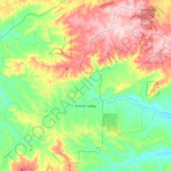
Name: Topografische Karte Inman Valley, Höhe, Relief.
Durchschnittliche Höhe: 212 m
Minimale Höhe: 49 m
Maximale Höhe: 443 m
Andere topografische Karten
Klicken Sie auf eine Karte, um ihre Topografie, ihre Höhe und ihr Relief anzuzeigen.
Myponga River
Australia > South Australia > The District Council of Yankalilla > Myponga > Myponga Beach
Durchschnittliche Höhe: 138 m
Kalumunda Forest Reserve
Australia > South Australia > The District Council of Yankalilla
Durchschnittliche Höhe: 265 m

Mount Hayfield
Australia > South Australia > The District Council of Yankalilla
Durchschnittliche Höhe: 278 m