
Topografische Karte Bayfield
Interaktive Karte
Klicken Sie auf die Karte, um die Höhe anzuzeigen.
Über diese Karte
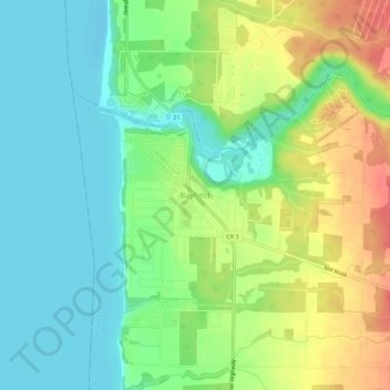
Name: Topografische Karte Bayfield, Höhe, Relief.
Ort: Bayfield, Bluewater, Huron County, Ontario, N0M 1G0, Canada (43.54100 -81.71590 43.58100 -81.67590)
Durchschnittliche Höhe: 199 m
Minimale Höhe: 173 m
Maximale Höhe: 240 m
Andere topografische Karten
Klicken Sie auf eine Karte, um ihre Topografie, ihre Höhe und ihr Relief anzuzeigen.
Varna
Canada > Ontario > Huron County > Bluewater
Varna, Bluewater, Huron County, Southwestern Ontario, Ontario, N0M 2R0, Canada
Durchschnittliche Höhe: 257 m
Blake
Canada > Ontario > Huron County > Bluewater
Blake, Bluewater, Huron County, Southwestern Ontario, Ontario, Canada
Durchschnittliche Höhe: 238 m
Hensall
Canada > Ontario > Huron County > Bluewater
Hensall, Bluewater, Huron County, Southwestern Ontario, Ontario, N0M 1X0, Canada
Durchschnittliche Höhe: 274 m
Dashwood
Canada > Ontario > Huron County > Bluewater
Dashwood, Bluewater, Huron County, Southwestern Ontario, Ontario, N0M 2T0, Canada
Durchschnittliche Höhe: 229 m