
Topografische Karte Cranleigh
Interaktive Karte
Klicken Sie auf die Karte, um die Höhe anzuzeigen.
Über diese Karte
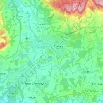
Name: Topografische Karte Cranleigh, Höhe, Relief.
Durchschnittliche Höhe: 78 m
Minimale Höhe: 24 m
Maximale Höhe: 257 m
Elevations range from a maximum of 240 m AOD (mean high water level) at the car park on Reynolds Hill in Winterfold Heath (a woodland in the north) to 41 m on the watercourse and the disused Wey and Arun Canal as they leave both the parish in the northwest extreme at the end of East Whipley Lane. The village centre lies at generally 50–70 m above AOD.