
Spenden
Rüste dich für dein nächstes Abenteuer:
Als Amazon-Partner verdient diese Seite an qualifizierten Käufen, ohne dass Ihnen zusätzliche Kosten entstehen.
Topografische Karte Watkins
Klicken Sie auf die Karte, um die Höhe anzuzeigen.
Spenden
Rüste dich für dein nächstes Abenteuer:
Als Amazon-Partner verdient diese Seite an qualifizierten Käufen, ohne dass Ihnen zusätzliche Kosten entstehen.
Über diese Karte
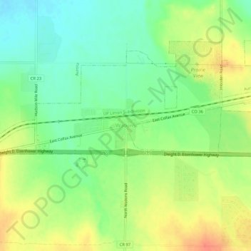
Name: Topografische Karte Watkins, Höhe, Relief.
Ort: Watkins, Adams County, Colorado, 80137, United States (39.72434 -104.62320 39.76434 -104.58320)
Durchschnittliche Höhe: 1’688 m
Minimale Höhe: 1’666 m
Maximale Höhe: 1’714 m
Spenden
Rüste dich für dein nächstes Abenteuer:
Als Amazon-Partner verdient diese Seite an qualifizierten Käufen, ohne dass Ihnen zusätzliche Kosten entstehen.
Andere topografische Karten
Klicken Sie auf eine Karte, um ihre Topografie, ihre Höhe und ihr Relief anzuzeigen.
Aurora
United States > Colorado > Adams County
Aurora's official elevation, posted on signs at the city limits, is 5,471 feet (1,668 m). However, the city spans a difference in elevation of nearly 1,000 feet (300 m). The lowest elevation of 5,285 feet (1,611 m) is found at the point where Sand Creek crosses the city limit in the northwest corner of the…
Durchschnittliche Höhe: 1’691 m
Spenden
Rüste dich für dein nächstes Abenteuer:
Als Amazon-Partner verdient diese Seite an qualifizierten Käufen, ohne dass Ihnen zusätzliche Kosten entstehen.
Bennett
United States > Colorado > Adams County
Bennett is located at coordinates 39°45′32″N 104°25′39″W / 39.7589°N 104.4275°W / 39.7589; -104.4275 at an elevation of 5486 at the intersection of State Highways 36 and 79, just north of Interstate 70.
Durchschnittliche Höhe: 1’692 m
Berkley
United States > Colorado > Adams County > Westminster > Berkley
Durchschnittliche Höhe: 1’596 m
Spenden
Rüste dich für dein nächstes Abenteuer:
Als Amazon-Partner verdient diese Seite an qualifizierten Käufen, ohne dass Ihnen zusätzliche Kosten entstehen.
Brighton
United States > Colorado > Adams County
Brighton is a suburb of Denver located at coordinates 39°59′07″N 104°49′14″W / 39.9853°N 104.8205°W / 39.9853; -104.8205 (Brighton, Colorado) at an elevation of 4,987 feet (1,520 m).
Durchschnittliche Höhe: 1’545 m
Aurora
United States > Colorado > Adams County
Aurora's official elevation, posted on signs at the city limits, is 5,471 feet (1,668 m). However, the city spans a difference in elevation of nearly 1,000 feet (300 m). The lowest elevation of 5,285 feet (1,611 m) is found at the point where Sand Creek crosses the city limit in the northwest corner of the…
Durchschnittliche Höhe: 1’691 m
Spenden
Rüste dich für dein nächstes Abenteuer:
Als Amazon-Partner verdient diese Seite an qualifizierten Käufen, ohne dass Ihnen zusätzliche Kosten entstehen.
Spenden
Rüste dich für dein nächstes Abenteuer:
Als Amazon-Partner verdient diese Seite an qualifizierten Käufen, ohne dass Ihnen zusätzliche Kosten entstehen.
Brighton
United States > Colorado > Adams County
Brighton is a suburb of Denver located at coordinates 39°59′07″N 104°49′14″W / 39.9853°N 104.8205°W / 39.9853; -104.8205 (Brighton, Colorado) at an elevation of 4,987 feet (1,520 m).
Durchschnittliche Höhe: 1’545 m
Bennett
United States > Colorado > Adams County
Bennett is located at coordinates 39°45′32″N 104°25′39″W / 39.7589°N 104.4275°W / 39.7589; -104.4275 at an elevation of 5486 at the intersection of State Highways 36 and 79, just north of Interstate 70.
Durchschnittliche Höhe: 1’692 m
Spenden
Rüste dich für dein nächstes Abenteuer:
Als Amazon-Partner verdient diese Seite an qualifizierten Käufen, ohne dass Ihnen zusätzliche Kosten entstehen.
Broomfield McKay Bike Park
United States > Colorado > Adams County > Broomfield
Durchschnittliche Höhe: 1’601 m
Spenden
Rüste dich für dein nächstes Abenteuer:
Als Amazon-Partner verdient diese Seite an qualifizierten Käufen, ohne dass Ihnen zusätzliche Kosten entstehen.
Derby
United States > Colorado > Adams County > Commerce City > Adams City
Durchschnittliche Höhe: 1’559 m