
Topografische Karte Zion National Park
Interaktive Karte
Klicken Sie auf die Karte, um die Höhe anzuzeigen.
Über diese Karte
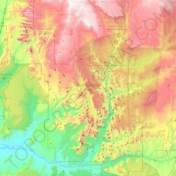
Name: Topografische Karte Zion National Park, Höhe, Relief.
Ort: Zion National Park, Washington County, Utah, United States (37.14135 -113.22829 37.50429 -112.86315)
Durchschnittliche Höhe: 1’877 m
Minimale Höhe: 1’055 m
Maximale Höhe: 2’876 m
The 8,726-foot (2,660 m) summit of Horse Ranch Mountain is the highest point in the park; the lowest point is the 3,666-foot (1,117 m) elevation of Coal Pits Wash, creating a relief of about 5,100 feet (1,600 m).
Andere topografische Karten
Klicken Sie auf eine Karte, um ihre Topografie, ihre Höhe und ihr Relief anzuzeigen.
Virgin
United States > Utah > Washington County
Virgin, Washington County, Utah, United States
Durchschnittliche Höhe: 1’251 m
Springdale
United States > Utah > Washington County
Springdale, Washington County, Utah, 84767, United States
Durchschnittliche Höhe: 1’354 m
Saint George
United States > Utah > Washington County
Saint George, Washington County, Utah, United States
Durchschnittliche Höhe: 929 m
Cottonwood Canyon Wilderness
United States > Utah > Washington County > Washington
Cottonwood Canyon Wilderness, Washington, Washington County, Utah, United States
Durchschnittliche Höhe: 1’213 m
Pine Valley Mountain Wilderness
United States > Utah > Washington County
Pine Valley Mountain Wilderness, Washington County, Utah, United States
Durchschnittliche Höhe: 2’125 m
Toquerville
United States > Utah > Washington County
Toquerville, Washington County, Utah, 84774, United States
Durchschnittliche Höhe: 1’301 m
Hurricane
United States > Utah > Washington County
Hurricane, Washington County, Utah, United States
Durchschnittliche Höhe: 1’154 m
Ivins
United States > Utah > Washington County > Ivins
Ivins, Washington County, Utah, 84738, United States
Durchschnittliche Höhe: 1’007 m