
Spenden
Rüste dich für dein nächstes Abenteuer:
Als Amazon-Partner verdient diese Seite an qualifizierten Käufen, ohne dass Ihnen zusätzliche Kosten entstehen.
Topografische Karte Cedar City
Klicken Sie auf die Karte, um die Höhe anzuzeigen.
Spenden
Rüste dich für dein nächstes Abenteuer:
Als Amazon-Partner verdient diese Seite an qualifizierten Käufen, ohne dass Ihnen zusätzliche Kosten entstehen.
Cedar City
Cedar City is located in the southeast Great Basin and is approximately 20 miles (32 km) north of the northeastern edge of the Mojave Desert. Its elevation of 5,846 feet (1,782 m) gives it a somewhat cooler climate compared to the nearby St. George region, though it retains cultural ties to the city —for example, they share a daily newspaper.
Spenden
Rüste dich für dein nächstes Abenteuer:
Als Amazon-Partner verdient diese Seite an qualifizierten Käufen, ohne dass Ihnen zusätzliche Kosten entstehen.
Über diese Karte
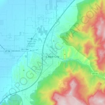
Name: Topografische Karte Cedar City, Höhe, Relief.
Ort: Cedar City, Iron County, Utah, United States (37.61847 -113.19797 37.74748 -113.01272)
Durchschnittliche Höhe: 1’975 m
Minimale Höhe: 1’676 m
Maximale Höhe: 2’866 m
Spenden
Rüste dich für dein nächstes Abenteuer:
Als Amazon-Partner verdient diese Seite an qualifizierten Käufen, ohne dass Ihnen zusätzliche Kosten entstehen.
Andere topografische Karten
Klicken Sie auf eine Karte, um ihre Topografie, ihre Höhe und ihr Relief anzuzeigen.
Spenden
Rüste dich für dein nächstes Abenteuer:
Als Amazon-Partner verdient diese Seite an qualifizierten Käufen, ohne dass Ihnen zusätzliche Kosten entstehen.