
Topografische Karte Moscow
Interaktive Karte
Klicken Sie auf die Karte, um die Höhe anzuzeigen.
Moscow
Along with the rest of the Idaho Panhandle, Moscow is in the Pacific Time Zone. The elevation of its city center is 2,579 feet (786 m) above sea level. Two major highways serve the city, passing through the city center: US-95 (north-south) and ID-8 (east-west). The Pullman–Moscow Regional Airport, four miles (6 km) west, provides limited commercial air service. The local newspaper is the Moscow-Pullman Daily News.
Über diese Karte
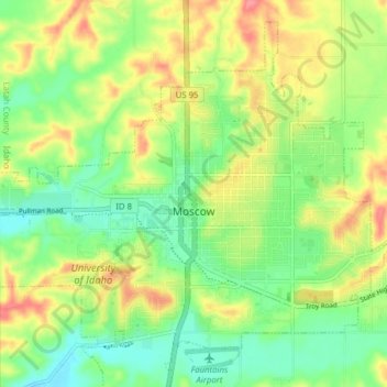
Name: Topografische Karte Moscow, Höhe, Relief.
Ort: Moscow, Latah County, Idaho, United States (46.69870 -117.03988 46.75861 -116.96054)
Durchschnittliche Höhe: 804 m
Minimale Höhe: 765 m
Maximale Höhe: 913 m
Andere topografische Karten
Klicken Sie auf eine Karte, um ihre Topografie, ihre Höhe und ihr Relief anzuzeigen.