
Spenden
Rüste dich für dein nächstes Abenteuer:
Als Amazon-Partner verdient diese Seite an qualifizierten Käufen, ohne dass Ihnen zusätzliche Kosten entstehen.
Topografische Karte Mount Sanford
Klicken Sie auf die Karte, um die Höhe anzuzeigen.
Spenden
Rüste dich für dein nächstes Abenteuer:
Als Amazon-Partner verdient diese Seite an qualifizierten Käufen, ohne dass Ihnen zusätzliche Kosten entstehen.
Über diese Karte
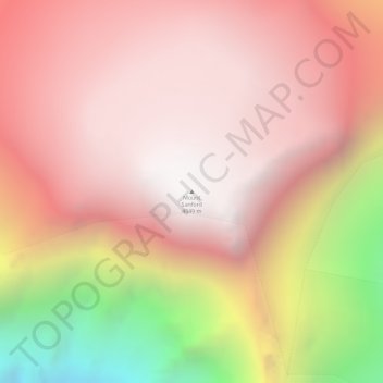
Name: Topografische Karte Mount Sanford, Höhe, Relief.
Ort: Mount Sanford, Unorganized Borough, Alaska, United States (62.21384 -144.12894 62.21394 -144.12884)
Durchschnittliche Höhe: 4’221 m
Minimale Höhe: 2’689 m
Maximale Höhe: 4’939 m
Spenden
Rüste dich für dein nächstes Abenteuer:
Als Amazon-Partner verdient diese Seite an qualifizierten Käufen, ohne dass Ihnen zusätzliche Kosten entstehen.
Andere topografische Karten
Klicken Sie auf eine Karte, um ihre Topografie, ihre Höhe und ihr Relief anzuzeigen.
Spenden
Rüste dich für dein nächstes Abenteuer:
Als Amazon-Partner verdient diese Seite an qualifizierten Käufen, ohne dass Ihnen zusätzliche Kosten entstehen.
Glacier Bay
United States > Alaska > Unorganized Borough
Glacier Bay is covered with 1,375 square miles (3,560 km2) of glaciers which accounts for 27% of the Park area with most glaciers originating in mountains with elevation range of 8,000–15,000 feet (2,400–4,600 m). There are over 50 named glaciers (both tidewater and terrestrial glaciers); 10 tide water…
Durchschnittliche Höhe: 402 m
Spenden
Rüste dich für dein nächstes Abenteuer:
Als Amazon-Partner verdient diese Seite an qualifizierten Käufen, ohne dass Ihnen zusätzliche Kosten entstehen.
Spenden
Rüste dich für dein nächstes Abenteuer:
Als Amazon-Partner verdient diese Seite an qualifizierten Käufen, ohne dass Ihnen zusätzliche Kosten entstehen.
Spenden
Rüste dich für dein nächstes Abenteuer:
Als Amazon-Partner verdient diese Seite an qualifizierten Käufen, ohne dass Ihnen zusätzliche Kosten entstehen.
Spenden
Rüste dich für dein nächstes Abenteuer:
Als Amazon-Partner verdient diese Seite an qualifizierten Käufen, ohne dass Ihnen zusätzliche Kosten entstehen.
Spenden
Rüste dich für dein nächstes Abenteuer:
Als Amazon-Partner verdient diese Seite an qualifizierten Käufen, ohne dass Ihnen zusätzliche Kosten entstehen.
Spenden
Rüste dich für dein nächstes Abenteuer:
Als Amazon-Partner verdient diese Seite an qualifizierten Käufen, ohne dass Ihnen zusätzliche Kosten entstehen.
Colony Glacier
United States > Alaska > Unorganized Borough > Anchorage
Durchschnittliche Höhe: 1’110 m
Spenden
Rüste dich für dein nächstes Abenteuer:
Als Amazon-Partner verdient diese Seite an qualifizierten Käufen, ohne dass Ihnen zusätzliche Kosten entstehen.
Spenden
Rüste dich für dein nächstes Abenteuer:
Als Amazon-Partner verdient diese Seite an qualifizierten Käufen, ohne dass Ihnen zusätzliche Kosten entstehen.
Kiska Island
United States > Alaska > Unorganized Borough
Renamed "Skira", the island was used as the setting for the Codemasters video game Operation Flashpoint: Dragon Rising. The fictionalized version of the island is relocated closer to Russia and China, but the island's topography is replicated almost exactly.
Durchschnittliche Höhe: 40 m
Spenden
Rüste dich für dein nächstes Abenteuer:
Als Amazon-Partner verdient diese Seite an qualifizierten Käufen, ohne dass Ihnen zusätzliche Kosten entstehen.
Umnak Island
United States > Alaska > Unorganized Borough
Umnak, the third largest of the Aleutian Islands after Unimak and Unalaska, lies in the Fox Islands of the Aleutian Islands of the Bering Sea, to the southwest of the larger island of Unalaska. It is approximately 70–72 miles (113–116 km) in length (117 kilometres (73 mi)) and 16 miles (26 km) wide on…
Durchschnittliche Höhe: 64 m
Spenden
Rüste dich für dein nächstes Abenteuer:
Als Amazon-Partner verdient diese Seite an qualifizierten Käufen, ohne dass Ihnen zusätzliche Kosten entstehen.
Saint George Island
United States > Alaska > Unorganized Borough > Saint George
Durchschnittliche Höhe: 24 m
Spenden
Rüste dich für dein nächstes Abenteuer:
Als Amazon-Partner verdient diese Seite an qualifizierten Käufen, ohne dass Ihnen zusätzliche Kosten entstehen.
Spenden
Rüste dich für dein nächstes Abenteuer:
Als Amazon-Partner verdient diese Seite an qualifizierten Käufen, ohne dass Ihnen zusätzliche Kosten entstehen.
Spenden
Rüste dich für dein nächstes Abenteuer:
Als Amazon-Partner verdient diese Seite an qualifizierten Käufen, ohne dass Ihnen zusätzliche Kosten entstehen.
Spenden
Rüste dich für dein nächstes Abenteuer:
Als Amazon-Partner verdient diese Seite an qualifizierten Käufen, ohne dass Ihnen zusätzliche Kosten entstehen.
Annette Island
United States > Alaska > Unorganized Borough
The lower elevations of Annette Island have a Marine west coast climate (Köppen Cfb), with windy and wet weather year-round, cool winters, and mild summers, and straddle the border between USDA Plant Hardiness Zones 7 and 8. Due to its southerly and maritime location, with an annual mean temperature of 47.7…
Durchschnittliche Höhe: 78 m
Spenden
Rüste dich für dein nächstes Abenteuer:
Als Amazon-Partner verdient diese Seite an qualifizierten Käufen, ohne dass Ihnen zusätzliche Kosten entstehen.
Kiska Island
United States > Alaska > Unorganized Borough
Renamed "Skira", the island was used as the setting for the Codemasters video game Operation Flashpoint: Dragon Rising. The fictionalized version of the island is relocated closer to Russia and China, but the island's topography is replicated near-exactly, with elements of the game designed around it, instead…
Durchschnittliche Höhe: 40 m
Lituya Bay
United States > Alaska > Unorganized Borough
The same topography that leads to the heavy tidal currents also created the tsunami with the highest runup against a hillside in recorded history. On the night of July 9, 1958, an earthquake caused a landslide in the Gilbert Inlet at the head of the bay, generating a massive megatsunami which had sufficient…
Durchschnittliche Höhe: 217 m
Saint Paul Island
United States > Alaska > Unorganized Borough > St. Paul
Saint Paul is the largest of the Pribilof Islands and lies the farthest north. With a width of 7.66 mi (12.33 km) at its widest point and a length of 13.5 mi (21.7 km) on its longest axis (which runs from northeast to southwest), it has a total area of 43 sq mi (110 km2). Volcanic in origin, Saint Paul…
Durchschnittliche Höhe: 10 m
Spenden
Rüste dich für dein nächstes Abenteuer:
Als Amazon-Partner verdient diese Seite an qualifizierten Käufen, ohne dass Ihnen zusätzliche Kosten entstehen.
Spenden
Rüste dich für dein nächstes Abenteuer:
Als Amazon-Partner verdient diese Seite an qualifizierten Käufen, ohne dass Ihnen zusätzliche Kosten entstehen.
Spenden
Rüste dich für dein nächstes Abenteuer:
Als Amazon-Partner verdient diese Seite an qualifizierten Käufen, ohne dass Ihnen zusätzliche Kosten entstehen.
Little Diomede Island
United States > Alaska > Unorganized Borough > Diomede > Diomede
Durchschnittliche Höhe: 160 m
Spenden
Rüste dich für dein nächstes Abenteuer:
Als Amazon-Partner verdient diese Seite an qualifizierten Käufen, ohne dass Ihnen zusätzliche Kosten entstehen.
Spenden
Rüste dich für dein nächstes Abenteuer:
Als Amazon-Partner verdient diese Seite an qualifizierten Käufen, ohne dass Ihnen zusätzliche Kosten entstehen.
Spenden
Rüste dich für dein nächstes Abenteuer:
Als Amazon-Partner verdient diese Seite an qualifizierten Käufen, ohne dass Ihnen zusätzliche Kosten entstehen.
Spenden
Rüste dich für dein nächstes Abenteuer:
Als Amazon-Partner verdient diese Seite an qualifizierten Käufen, ohne dass Ihnen zusätzliche Kosten entstehen.
Spenden
Rüste dich für dein nächstes Abenteuer:
Als Amazon-Partner verdient diese Seite an qualifizierten Käufen, ohne dass Ihnen zusätzliche Kosten entstehen.
Kasatochi Island
United States > Alaska > Unorganized Borough
Kasatochi Island is a member of the Aleutian Islands, which lie above a narrow ridge that separates the Bering Sea from the North Pacific. It lies at the Atka Pass northwest of the western tip of Atka Island and east of Great Sitkin Island. It is at 52.177° N latitude and 175.508° W longitude, with a summit…
Durchschnittliche Höhe: 53 m
Spenden
Rüste dich für dein nächstes Abenteuer:
Als Amazon-Partner verdient diese Seite an qualifizierten Käufen, ohne dass Ihnen zusätzliche Kosten entstehen.