
Topografische Karte Dakota County
Interaktive Karte
Klicken Sie auf die Karte, um die Höhe anzuzeigen.
Über diese Karte
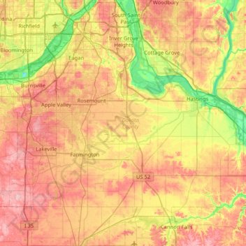
Name: Topografische Karte Dakota County, Höhe, Relief.
Ort: Dakota County, Minnesota, United States (44.47118 -93.32983 44.92329 -92.73220)
Durchschnittliche Höhe: 278 m
Minimale Höhe: 188 m
Maximale Höhe: 374 m
Andere topografische Karten
Klicken Sie auf eine Karte, um ihre Topografie, ihre Höhe und ihr Relief anzuzeigen.
Fort Snelling State Park
United States > Minnesota > Dakota County > Eagan
Fort Snelling State Park, Eagan, Dakota County, Minnesota, United States
Durchschnittliche Höhe: 246 m
Lake Rebecca
United States > Minnesota > Dakota County > Hastings
Lake Rebecca, Hastings, Dakota County, Minnesota, United States
Durchschnittliche Höhe: 230 m
Eagan
United States > Minnesota > Dakota County > Eagan
Eagan, Dakota County, Minnesota, United States
Durchschnittliche Höhe: 267 m
Roseport
United States > Minnesota > Dakota County > Inver Grove Heights > Roseport
Roseport, Inver Grove Heights, Dakota County, Minnesota, United States
Durchschnittliche Höhe: 272 m
Lilydale
United States > Minnesota > Dakota County
Lilydale, Dakota County, Minnesota, United States
Durchschnittliche Höhe: 257 m
Rosemount
United States > Minnesota > Dakota County
Rosemount, Dakota County, Minnesota, 55068, United States
Durchschnittliche Höhe: 287 m