
Topografische Karte Cadillac Mountain
Interaktive Karte
Klicken Sie auf die Karte, um die Höhe anzuzeigen.
Über diese Karte
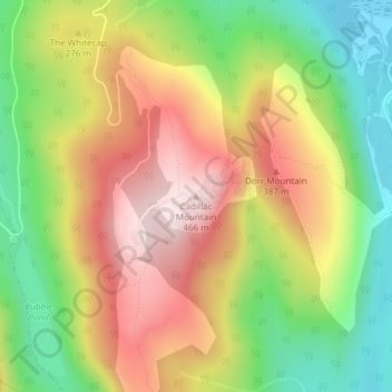
Name: Topografische Karte Cadillac Mountain, Höhe, Relief.
Durchschnittliche Höhe: 233 m
Minimale Höhe: 15 m
Maximale Höhe: 461 m
Cadillac Mountain is located on Mount Desert Island, within Acadia National Park, in the U.S. state of Maine. With an elevation of 1,530 feet (470 meters), its summit is the highest point in Hancock County and the highest within 25 miles (40 km) of the Atlantic shoreline of the North American continent between the Cape Breton Highlands, Nova Scotia, and peaks in Mexico. It is known as the first place in the continental U.S. to see the sunrise, although that is only true for a portion of the year.
Andere topografische Karten
Klicken Sie auf eine Karte, um ihre Topografie, ihre Höhe und ihr Relief anzuzeigen.
Acadia National Park
United States > Maine > Hancock County > Bar Harbor
Acadia National Park, Bar Harbor, Hancock County, Maine, 04609, United States
Durchschnittliche Höhe: 9 m
Fresh Meadow
United States > Maine > Hancock County > Bar Harbor
Fresh Meadow, Bar Harbor, Hancock County, Maine, United States
Durchschnittliche Höhe: 17 m
Salsbury Cove
United States > Maine > Hancock County > Bar Harbor
Salsbury Cove, Bar Harbor, Hancock County, Maine, United States
Durchschnittliche Höhe: 15 m