
Topografische Karte Harris Neck National Wildlife Refuge
Interaktive Karte
Klicken Sie auf die Karte, um die Höhe anzuzeigen.
Über diese Karte
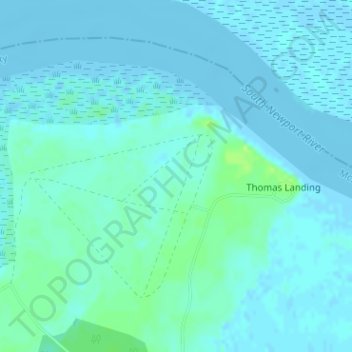
Name: Topografische Karte Harris Neck National Wildlife Refuge, Höhe, Relief.
Durchschnittliche Höhe: 3 m
Minimale Höhe: -3 m
Maximale Höhe: 13 m
Andere topografische Karten
Klicken Sie auf eine Karte, um ihre Topografie, ihre Höhe und ihr Relief anzuzeigen.
Black Island
United States > Georgia > McIntosh County
Black Island, McIntosh County, Georgia, United States
Durchschnittliche Höhe: 2 m
Darien
United States > Georgia > McIntosh County
Darien, McIntosh County, Georgia, 31305, United States
Durchschnittliche Höhe: 3 m
Blackbeard Island
United States > Georgia > McIntosh County
Blackbeard Island, McIntosh County, Georgia, United States
Durchschnittliche Höhe: 2 m
Pico Island
United States > Georgia > McIntosh County > Darien
Pico Island, Darien, McIntosh County, Georgia, 31305, United States
Durchschnittliche Höhe: 4 m