
Topografische Karte Pangasugan
Interaktive Karte
Klicken Sie auf die Karte, um die Höhe anzuzeigen.
Über diese Karte
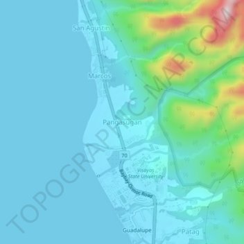
Name: Topografische Karte Pangasugan, Höhe, Relief.
Durchschnittliche Höhe: 61 m
Minimale Höhe: 0 m
Maximale Höhe: 428 m
Andere topografische Karten
Klicken Sie auf eine Karte, um ihre Topografie, ihre Höhe und ihr Relief anzuzeigen.
Mailhi
Philippines > Leyte > Baybay
Mailhi, Baybay, 5th District, Leyte, Eastern Visayas, 6521, Philippines
Durchschnittliche Höhe: 236 m
Kabalasan
Philippines > Leyte > Baybay
Kabalasan, Baybay, 5th District, Leyte, Eastern Visayas, Philippines
Durchschnittliche Höhe: 44 m
Patag
Philippines > Leyte > Baybay
Patag, Baybay, Leyte 5th District, Leyte, Eastern Visayas, 6521, Philippines
Durchschnittliche Höhe: 64 m
Sea of Clouds
Philippines > Leyte > Baybay > Cuatro de Agosto
Sea of Clouds, Tacloban-Baybay Road, Crossing, Cuatro de Agosto, Baybay, Leyte 5th District, Leyte, Eastern Visayas, 6512, Philippines
Durchschnittliche Höhe: 187 m