
Topografische Karte Chandratal Lake
Klicken Sie auf die Karte, um die Höhe anzuzeigen.
Über diese Karte
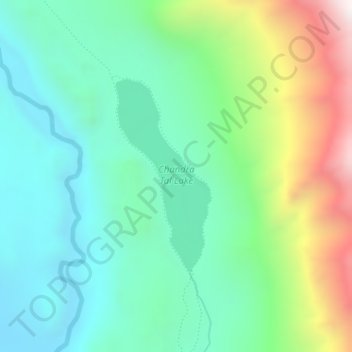
Name: Topografische Karte Chandratal Lake, Höhe, Relief.
Durchschnittliche Höhe: 4’403 m
Minimale Höhe: 4’091 m
Maximale Höhe: 5’168 m
Andere topografische Karten
Klicken Sie auf eine Karte, um ihre Topografie, ihre Höhe und ihr Relief anzuzeigen.
Indrasan
India > Himachal Pradesh > Lahul
Mount Indrasan is located at an altitude of 6221 metres above sea level in Kullu district, Himachal Pradesh. Mt. Indrasan is considered as the most difficult mountain to climb in the Pir Panjal range of the Himalayas because of the challenges involved in scaling it. It was first climbed on October 13, 1962, by…
Durchschnittliche Höhe: 5’374 m
Darcha
India > Himachal Pradesh > Lahul
Darcha (elevation 3,360 m or 11,020 ft) is a pair of villages (Darcha Sumdo and Darach Dangma) on the Bhaga River in the Lahaul sub-division in the Lahaul and Spiti district in the Indian state of Himachal Pradesh. It is the northernmost permanent settlement in Himachal Pradesh along the Manali-Leh Highway.…
Durchschnittliche Höhe: 3’702 m
Keylang
India > Himachal Pradesh > Lahul
Kyelang is accessible from Manali via the Manali-Leh Highway, a part of NH21. It is located about 71 km (44 mi) north of Manali at an altitude of 3,080 m (10,100 ft) and used to remain cut off from the outside world for six months from late October to mid-May due to heavy snowfall at Rohtang pass until the…
Durchschnittliche Höhe: 3’823 m
Darcha
India > Himachal Pradesh > Lahul
Darcha (elevation 3,360 m or 11,020 ft) is a pair of villages (Darcha Sumdo and Darach Dangma) on the Bhaga River in the Lahaul sub-division in the Lahaul and Spiti district in the Indian state of Himachal Pradesh. It is the northernmost permanent settlement in Himachal Pradesh along the Manali-Leh Highway.…
Durchschnittliche Höhe: 3’702 m