Geolokalisieren

Topografische Karte Barton-under-Needwood

Klicken Sie auf die Karte, um die Höhe anzuzeigen.

Über diese Karte

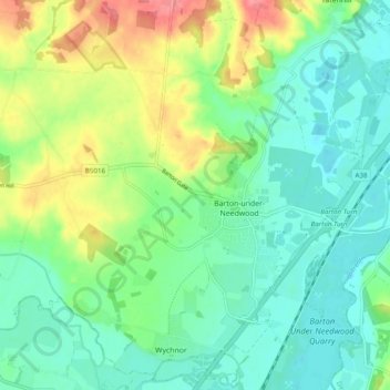
Name: Topografische Karte Barton-under-Needwood, Höhe, Relief.

Ort: Barton-under-Needwood, East Staffordshire, Staffordshire, England, United Kingdom (52.74096 -1.77929 52.79127 -1.68253)

Durchschnittliche Höhe: 69 m

Minimale Höhe: 42 m

Maximale Höhe: 126 m

Andere topografische Karten

Klicken Sie auf eine Karte, um ihre Topografie, ihre Höhe und ihr Relief anzuzeigen.

Burton upon Trent

United Kingdom > England > Staffordshire > East Staffordshire

Burton is about 109 miles (175 km) north west of London, about 30 miles north east of Birmingham, the UK's second largest city and about 23 miles east of the county town Stafford. It is at the easternmost border of the county of Staffordshire with Derbyshire, its suburbs and the course of the River Trent…

Durchschnittliche Höhe: 69 m

Admaston

United Kingdom > England > Staffordshire > East Staffordshire

Durchschnittliche Höhe: 103 m

Burton upon Trent

United Kingdom > England > Staffordshire > East Staffordshire

Burton is about 109 miles (175 km) north west of London, about 30 miles north east of Birmingham, the UK's second largest city and about 23 miles east of the county town Stafford. It is at the easternmost border of the county of Staffordshire with Derbyshire, its suburbs and the course of the River Trent…

Durchschnittliche Höhe: 69 m

Fauld

United Kingdom > England > Staffordshire > East Staffordshire > Hanbury

Durchschnittliche Höhe: 88 m

Stretton

United Kingdom > England > Staffordshire > East Staffordshire

Durchschnittliche Höhe: 55 m

Stanton

United Kingdom > England > Staffordshire > East Staffordshire

Durchschnittliche Höhe: 222 m

Gratwich

United Kingdom > England > Staffordshire > East Staffordshire > Kingstone

Durchschnittliche Höhe: 143 m

Burton upon Trent

United Kingdom > England > Staffordshire > East Staffordshire

Burton is about 109 miles (175 km) north west of London, about 30 miles north east of Birmingham, the UK's second largest city and about 23 miles east of the county town Stafford. It is at the easternmost border of the county of Staffordshire with Derbyshire, its suburbs and the course of the River Trent…

Durchschnittliche Höhe: 69 m

Stubwood

United Kingdom > England > Staffordshire > East Staffordshire > Denstone

Durchschnittliche Höhe: 113 m

Bramshall

United Kingdom > England > Staffordshire > East Staffordshire

Durchschnittliche Höhe: 121 m

Rüste dich für dein nächstes Abenteuer:

🔭Spektive - Detailreiche Beobachtungen aus grosser Distanz
🧦Wandersocken - Atmungsaktive Socken für Komfort auf langen Strecken
🌦️Regenjacken für Wanderer - Wasserdichte Jacken für wechselhaftes Wetter
🥾Wanderschuhe für Damen - Atmungsaktive Gore-Tex Schuhe für höchsten Tragekomfort
💡Taschenlampen für Camping - Leistungsstarke Lampen für Basis‑ und Trekkingcampings

Als Amazon-Partner verdient diese Seite an qualifizierten Käufen, ohne dass Ihnen zusätzliche Kosten entstehen.