
Topografische Karte Norwood
Interaktive Karte
Klicken Sie auf die Karte, um die Höhe anzuzeigen.
Über diese Karte
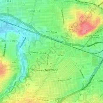
Name: Topografische Karte Norwood, Höhe, Relief.
Ort: Norwood, Hamilton County, Ohio, 45212, United States (39.14482 -84.47367 39.17819 -84.43460)
Durchschnittliche Höhe: 196 m
Minimale Höhe: 161 m
Maximale Höhe: 246 m
The earliest humans in the area now known as Norwood are believed to have been Pre-Columbian era people of the Adena culture. Norwood Mound, a prehistoric earthwork mound built by the Adena, is located in Norwood and listed on the National Register of Historic Places. The Adena constructed the mound at the location of Norwood's present-day Water Tower Park, which is the highest land elevation in the city. Archaeologists believe the mound was built at this site due to the high elevation and was used by the Adena for religious ceremonies and smoke signaling.
Andere topografische Karten
Klicken Sie auf eine Karte, um ihre Topografie, ihre Höhe und ihr Relief anzuzeigen.
Cincinnati
United States > Ohio > Hamilton County
Cincinnati, Hamilton County, Ohio, United States
Durchschnittliche Höhe: 222 m
Symmes Township Park
United States > Ohio > Hamilton County > Loveland
Symmes Township Park, Loveland, Symmes Township, Hamilton County, Ohio, United States
Durchschnittliche Höhe: 226 m
Amberley Village
United States > Ohio > Hamilton County
Amberley Village, Hamilton County, Ohio, United States
Durchschnittliche Höhe: 226 m
Forest Park
United States > Ohio > Hamilton County
Forest Park, Hamilton County, Ohio, United States
Durchschnittliche Höhe: 234 m
Montgomery Heights
United States > Ohio > Hamilton County > Montgomery > Montgomery Heights
Montgomery Heights, Montgomery, Hamilton County, Ohio, 45242-5324, United States
Durchschnittliche Höhe: 241 m
Northgate
United States > Ohio > Hamilton County > Northgate
Northgate, Colerain Township, Hamilton County, Ohio, United States
Durchschnittliche Höhe: 264 m