
Topografische Karte Uttarakhand
Interaktive Karte
Klicken Sie auf die Karte, um die Höhe anzuzeigen.
Über diese Karte
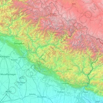
Name: Topografische Karte Uttarakhand, Höhe, Relief.
Ort: Uttarakhand, India (28.72432 77.57133 31.45902 81.04479)
Durchschnittliche Höhe: 2’107 m
Minimale Höhe: 160 m
Maximale Höhe: 7’442 m
Uttarakhand lies on the southern slope of the Himalaya range, and the climate and vegetation vary greatly with elevation, from glaciers at the highest elevations to subtropical forests at the lower elevations. The highest elevations are covered by ice and bare rock. Below them, between 3,000 and 5,000 metres (9,800 and 16,400 ft) are the western Himalayan alpine shrub and meadows. The temperate western Himalayan subalpine conifer forests grow just below the tree line. At 3,000 to 2,600 metres (9,800 to 8,500 ft) elevation they transition to the temperate western Himalayan broadleaf forests, which lie in a belt from 2,600 to 1,500 metres (8,500 to 4,900 ft) elevation. Below 1,500 metres (4,900 ft) elevation lie the Himalayan subtropical pine forests. The Upper Gangetic Plains moist deciduous forests and the drier Terai-Duar savanna and grasslands cover the lowlands along the Uttar Pradesh border in a belt locally known as Bhabar. These lowland forests have mostly been cleared for agriculture, but a few pockets remain.
Andere topografische Karten
Klicken Sie auf eine Karte, um ihre Topografie, ihre Höhe und ihr Relief anzuzeigen.
Bengaluru
India > Karnataka > Bangalore North
Bengaluru, Bangalore North, Bengaluru Urban District, Karnataka, India
Durchschnittliche Höhe: 881 m
Chennai
India > Tamil Nadu > Chennai
Chennai, Chennai District, Tamil Nadu, India
Durchschnittliche Höhe: 8 m
Coimbatore
India > Tamil Nadu > Coimbatore North
Coimbatore, Coimbatore North, Coimbatore District, Tamil Nadu, 641001, India
Durchschnittliche Höhe: 452 m
3d
India > Rajasthan > Ganganagar Tehsil > 1 LNP
3d, 1 LNP, Ganganagar Tehsil, Sri Ganganagar District, Rajasthan, India
Durchschnittliche Höhe: 178 m
North Sentinel Island
India > Andaman and Nicobar Islands > Ferrargunj
North Sentinel Island, Ferrargunj, South Andaman District, Andaman and Nicobar Islands, India
Durchschnittliche Höhe: 20 m
Gurgaon
India > Haryana > Gurugram District
Gurgaon, Gurugram District, Haryana, India
Durchschnittliche Höhe: 237 m
Kolkata
Kolkata, Kolkata District, West Bengal, 700073, India
Durchschnittliche Höhe: 5 m
Western Ghats
Western Ghats, Idukki, Kerala, 685614, India
Durchschnittliche Höhe: 2’225 m
Prayagraj
India > Uttar Pradesh > Prayagraj
Prayagraj, Prayagraj District, Uttar Pradesh, 211001, India
Durchschnittliche Höhe: 91 m
Srinagar
India > Jammu and Kashmir > Srinagar (South)
Srinagar, Srinagar (South), Srinagar District, Jammu and Kashmir, 190001, India
Durchschnittliche Höhe: 1’805 m
Thiruvananthapuram
India > Kerala > Thiruvananthapuram
Thiruvananthapuram, Thiruvananthapuram District, Kerala, 695001, India
Durchschnittliche Höhe: 33 m
Varana
India > Gujarat > Sami Taluka
Varana, Sami Taluka, Patan District, Gujarat, India
Durchschnittliche Höhe: 32 m
riyuni tal
India > Uttarakhand > Ranikhet > Majkhali
riyuni tal, Majkhali, Ranikhet, Almora District, Uttarakhand, 263652, India
Durchschnittliche Höhe: 1’567 m
Vagamon Lake
India > Kerala > Peerumade > Vagamon
Vagamon Lake, Vagamon, Peerumade, Idukki District, Kerala, India
Durchschnittliche Höhe: 976 m
Thodupuzha
India > Kerala > Thodupuzha
Thodupuzha, Idukki District, Kerala, 685584, India
Durchschnittliche Höhe: 53 m
Jakhni
India > Uttarakhand > Jakholi
Jakhni, Jakholi, Rudraprayag District, Uttarakhand, 246475, India
Durchschnittliche Höhe: 1’265 m
Chennai
Chennai, Chennai District, Tamil Nadu, 600001, India
Durchschnittliche Höhe: 7 m
Bachupally mandal
Bachupally mandal, Medchal–Malkajgiri District, Telangana, 500090, India
Durchschnittliche Höhe: 593 m
Thoppampatti
India > Tamil Nadu > Manapparai > Annampatty
Thoppampatti, Annampatty, Manapparai, Tiruchirappalli District, Tamil Nadu, India
Durchschnittliche Höhe: 181 m
Lucknow
India > Uttar Pradesh > Lucknow
Lucknow, Lucknow District, Uttar Pradesh, 226027, India
Durchschnittliche Höhe: 120 m
Pune
India > Maharashtra > Pune City > Pune
Pune, Pune City, Pune District, Maharashtra, 411001, India
Durchschnittliche Höhe: 641 m
Jhurjhuri
India > Madhya Pradesh > Panagar Tahsil
Jhurjhuri, Panagar Tahsil, Jabalpur District, Madhya Pradesh, India
Durchschnittliche Höhe: 395 m
Kambalipura
India > Karnataka > Anekal > Kambalipura
Kambalipura, Anekal, Bengaluru Urban, Karnataka, India
Durchschnittliche Höhe: 886 m
ghiri
India > Uttarakhand > Pauri > Agaroda
ghiri, Agaroda, Pauri, Pauri Garhwal District, Uttarakhand, 246176, India
Durchschnittliche Höhe: 1’344 m
Mambakkam
India > Tamil Nadu > Tiruporur
Mambakkam, Tiruporur, Chengalpattu District, Tamil Nadu, 600127, India
Durchschnittliche Höhe: 16 m
Pimpri-Chinchwad
India > Maharashtra > Haveli
Pimpri-Chinchwad, Haveli, Pune District, Maharashtra, 411089, India
Durchschnittliche Höhe: 605 m