
Topografische Karte Sugarloaf Peak
Interaktive Karte
Klicken Sie auf die Karte, um die Höhe anzuzeigen.
Über diese Karte
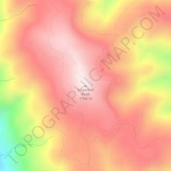
Name: Topografische Karte Sugarloaf Peak, Höhe, Relief.
Ort: Sugarloaf Peak, Chelan County, Washington, United States (47.75714 -120.52819 47.75724 -120.52809)
Durchschnittliche Höhe: 1’550 m
Minimale Höhe: 1’111 m
Maximale Höhe: 1’758 m
Andere topografische Karten
Klicken Sie auf eine Karte, um ihre Topografie, ihre Höhe und ihr Relief anzuzeigen.
Wenatchee
United States > Washington > Chelan County > Wenatchee
Wenatchee, Chelan County, Washington, 98801, United States
Durchschnittliche Höhe: 302 m
Lake Julius
United States > Washington > Chelan County
Lake Julius, Chelan County, Washington, United States
Durchschnittliche Höhe: 1’697 m
Mount David
United States > Washington > Chelan County
Mount David, Chelan County, Washington, United States
Durchschnittliche Höhe: 1’736 m
Cashmere
United States > Washington > Chelan County > Cashmere
Cashmere, Chelan County, Washington, United States
Durchschnittliche Höhe: 298 m