Geolokalisieren

Topografische Karte Livingston

Interaktive Karte

Klicken Sie auf die Karte, um die Höhe anzuzeigen.

Über diese Karte

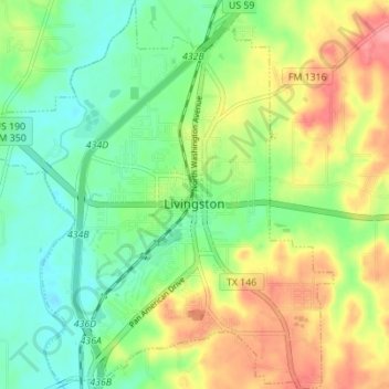
Name: Topografische Karte Livingston, Höhe, Relief.

Ort: Livingston, Polk County, Texas, United States (30.68262 -94.97029 30.74201 -94.90823)

Durchschnittliche Höhe: 63 m

Minimale Höhe: 28 m

Maximale Höhe: 116 m

Elevation: 148 ft

Wikipedia (CC-BY-SA 3.0)

Andere topografische Karten

Klicken Sie auf eine Karte, um ihre Topografie, ihre Höhe und ihr Relief anzuzeigen.

Tobacco Patch

United States > Texas > Polk County

Tobacco Patch, Polk County, Texas, United States

Durchschnittliche Höhe: 43 m

Israel

United States > Texas > Polk County

Israel, Polk County, Texas, United States

Durchschnittliche Höhe: 87 m

Seven Oaks

United States > Texas > Polk County

Seven Oaks, Polk County, Texas, United States

Durchschnittliche Höhe: 68 m

Goodrich

United States > Texas > Polk County

Goodrich, Polk County, Texas, United States

Durchschnittliche Höhe: 38 m