
Topografische Karte Spring Gulch
Interaktive Karte
Klicken Sie auf die Karte, um die Höhe anzuzeigen.
Über diese Karte
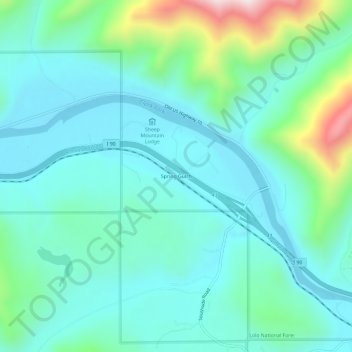
Name: Topografische Karte Spring Gulch, Höhe, Relief.
Ort: Spring Gulch, Mineral County, Montana, United States (47.21021 -115.00069 47.25021 -114.96069)
Durchschnittliche Höhe: 926 m
Minimale Höhe: 798 m
Maximale Höhe: 1’427 m
Andere topografische Karten
Klicken Sie auf eine Karte, um ihre Topografie, ihre Höhe und ihr Relief anzuzeigen.
Quartz
United States > Montana > Mineral County
Quartz, Mineral County, Montana, United States
Durchschnittliche Höhe: 979 m
Alberton
United States > Montana > Mineral County
Alberton, Mineral County, Montana, United States
Durchschnittliche Höhe: 1’099 m
St. Regis
United States > Montana > Mineral County > St. Regis
St. Regis, Mineral County, Montana, 59866, United States
Durchschnittliche Höhe: 840 m
Haugan
United States > Montana > Mineral County > Haugan
Haugan, Mineral County, Montana, United States
Durchschnittliche Höhe: 1’044 m