Geolokalisieren

Topografische Karte 镇宁布依族苗族自治县

Interaktive Karte

Klicken Sie auf die Karte, um die Höhe anzuzeigen.

Über diese Karte

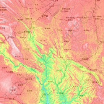
Name: Topografische Karte 镇宁布依族苗族自治县, Höhe, Relief.

Ort: 镇宁布依族苗族自治县, 安顺市, 贵州省, 中国 (25.42544 105.58734 26.17327 106.01721)

Durchschnittliche Höhe: 1’139 m

Minimale Höhe: 363 m

Maximale Höhe: 1’827 m

地势北高南低,坡度变化较大。县境东北部的茅草坡山主峰为全县最高点,海拔1678米,南端良田乡北盘江出县界处为最低点,海拔356米,相对高差 1322米。镇宁是一个典型的山区县,山地面积1098平方千米,占全县总面积63.91%;丘陵面积157.8平方千米,占全县总面积9.19%。岩溶地貌分布广,占全县总面积60%以上,是贵州省岩溶地貌发育最典型的地区之一。境内大小河流31条,总长518多公里,径流总量9.3亿立方米。

Wikipedia (CC-BY-SA 3.0)

Andere topografische Karten

Klicken Sie auf eine Karte, um ihre Topografie, ihre Höhe und ihr Relief anzuzeigen.

白水镇

中国 > 贵州省 > 安顺市

白水镇, 安顺市, 贵州省, 中国

Durchschnittliche Höhe: 1’043 m

乐平镇

中国 > 贵州省 > 安顺市

乐平镇, 安顺市, 贵州省, 中国

Durchschnittliche Höhe: 1’383 m

齐伯镇

中国 > 贵州省 > 安顺市

齐伯镇, 安顺市, 贵州省, 中国

Durchschnittliche Höhe: 1’279 m

双堡镇

中国 > 贵州省 > 安顺市

双堡镇, 安顺市, 贵州省, 中国

Durchschnittliche Höhe: 1’278 m

付家屯

中国 > 贵州省 > 安顺市

付家屯, 西秀区, 安顺市, 贵州省, 中国

Durchschnittliche Höhe: 1’371 m

西秀区

中国 > 贵州省 > 安顺市

西秀区, 安顺市, 贵州省, 561000, 中国

Durchschnittliche Höhe: 1’322 m

普定县

中国 > 贵州省 > 安顺市

普定县, 安顺市, 贵州省, 中国

Durchschnittliche Höhe: 1’425 m

关岭布依族苗族自治县

中国 > 贵州省 > 安顺市

关岭布依族苗族自治县, 安顺市, 贵州省, 中国

Durchschnittliche Höhe: 1’121 m

哑里

中国 > 贵州省 > 安顺市 > 哑里

哑里, 安顺市, 贵州省, 中国

Durchschnittliche Höhe: 1’527 m