Topografische Karte Castleknock
Interaktive Karte
Klicken Sie auf die Karte, um die Höhe anzuzeigen.
Über diese Karte
![Topografische Karte Castleknock, Höhe, Relief](/pub/maps/node/mvgt/sjpjx18/thumbnail.jpg)
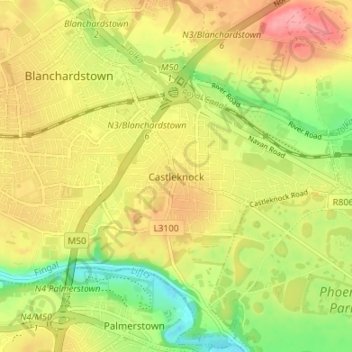
Name: Topografische Karte Castleknock, Höhe, Relief.
Ort: Castleknock, Fingal, Dublin 15, Leinster, D15 VY32, Irland (53.35296 -6.38247 53.39296 -6.34247)
Durchschnittliche Höhe: 55 m
Minimale Höhe: 7 m
Maximale Höhe: 98 m
Andere topografische Karten
Klicken Sie auf eine Karte, um ihre Topografie, ihre Höhe und ihr Relief anzuzeigen.
![Topografische Karte Lower Lough Bray, Höhe, Relief](/pub/maps/way/xt5k/ln54nh/icon.jpg)
Lower Lough Bray
Lower Lough Bray, Powerscourt ED, The Municipal District of Bray, County Wicklow, Leinster, Irland
Durchschnittliche Höhe: 455 m
![Topografische Karte Eagle's Crag, Höhe, Relief](/pub/maps/way/989m/bw3hq1h/icon.jpg)
Eagle's Crag
Eagle's Crag, Powerscourt ED, The Municipal District of Bray, County Wicklow, Leinster, Irland
Durchschnittliche Höhe: 490 m
![Topografische Karte The Municipal District of Wicklow, Höhe, Relief](/pub/maps/relation/nv51/3qfc51/icon.jpg)
The Municipal District of Wicklow
The Municipal District of Wicklow, County Wicklow, Leinster, Irland
Durchschnittliche Höhe: 263 m
![Topografische Karte Glencullen ED, Höhe, Relief](/pub/maps/relation/dcmt/hjdttp/icon.jpg)
Glencullen ED
Glencullen ED, Dublin 18, Dún Laoghaire-Rathdown, County Dublin, Leinster, Irland
Durchschnittliche Höhe: 137 m
![Topografische Karte Dingle - Daingean Uí Chúis, Höhe, Relief](/pub/maps/node/pkgt/mg1ppnh/icon.jpg)
Dingle - Daingean Uí Chúis
Irland > Dingle - Daingean Uí Chúis
Dingle - Daingean Uí Chúis, County Kerry, Munster, Irland
Durchschnittliche Höhe: 77 m
![Topografische Karte Attimonmore South, Höhe, Relief](/pub/maps/relation/cttj/lq1ggt/icon.jpg)
Attimonmore South
Attimonmore South, Cloonkeen ED, Athenry-Oranmore Municipal District, County Galway, Connacht, Irland
Durchschnittliche Höhe: 75 m