
Topografische Karte Battle Mountain
Interaktive Karte
Klicken Sie auf die Karte, um die Höhe anzuzeigen.
Über diese Karte
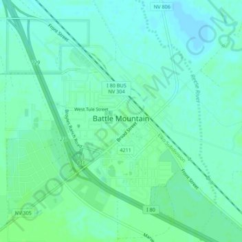
Name: Topografische Karte Battle Mountain, Höhe, Relief.
Ort: Battle Mountain, Lander County, Nevada, United States (40.62577 -116.95528 40.65724 -116.92624)
Durchschnittliche Höhe: 1’376 m
Minimale Höhe: 1’372 m
Maximale Höhe: 1’380 m
Battle Mountain's climate is cool semi-arid (Köppen climate classification BSk), receiving just enough precipitation to avoid arid classification. Due to aridity and high elevation, the area commonly experiences large diurnal temperature variation, particularly in summer, when it averages almost 45 °F or 25 °C. The monthly daily average temperature ranges from 29.8 °F or −1.2 °C in January to 73.6 °F or 23.1 °C in July. There are, on average, fourteen afternoons of 100 °F or 37.8 °C or hotter maxima, 74 afternoons of 90 °F or 32.2 °C or hotter maxima, eleven afternoons where the high does not rise above freezing, and seven mornings falling to or below 0 °F or −17.8 °C annually; the average window for freezing temperatures is September 16 to May 29.[12] By far the coldest recorded month has been January 1949, with a mean of 4.6 °F (−15.2 °C) and a mean minimum of −12.0 °F (−24.4 °C) – between January 2 and February 3, the temperature did not reach freezing, whereas during the winter of 2011/2012 every single day topped freezing. The hottest month has been July 2013, with a mean of 79.9 °F (26.6 °C) and a mean maximum of 100.1 °F (37.8 °C), although July 2007's maximum was even hotter at 100.8 °F (38.2 °C).
Andere topografische Karten
Klicken Sie auf eine Karte, um ihre Topografie, ihre Höhe und ihr Relief anzuzeigen.
Kingston
United States > Nevada > Lander County
Kingston, Lander County, Nevada, United States
Durchschnittliche Höhe: 1’964 m
Austin
United States > Nevada > Lander County
Austin, Lander County, Nevada, United States
Durchschnittliche Höhe: 2’076 m