
Topografische Karte Breathitt County
Interaktive Karte
Klicken Sie auf die Karte, um die Höhe anzuzeigen.
Über diese Karte
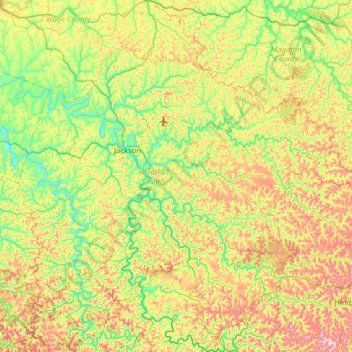
Name: Topografische Karte Breathitt County, Höhe, Relief.
Ort: Breathitt County, Kentucky, United States (37.33004 -83.58037 37.69994 -82.94854)
Durchschnittliche Höhe: 341 m
Minimale Höhe: 201 m
Maximale Höhe: 590 m
Andere topografische Karten
Klicken Sie auf eine Karte, um ihre Topografie, ihre Höhe und ihr Relief anzuzeigen.
Canoe
United States > Kentucky > Breathitt County
Canoe, Breathitt County, Kentucky, United States
Durchschnittliche Höhe: 299 m
Haddix
United States > Kentucky > Breathitt County
Haddix, Breathitt County, Kentucky, United States
Durchschnittliche Höhe: 295 m