Geolokalisieren

Topografische Karte Brooken Mountain

Interaktive Karte

Klicken Sie auf die Karte, um die Höhe anzuzeigen.

Über diese Karte

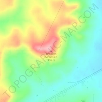
Name: Topografische Karte Brooken Mountain, Höhe, Relief.

Ort: Brooken Mountain, Haskell County, Oklahoma, United States (35.23199 -95.40280 35.23209 -95.40270)

Durchschnittliche Höhe: 250 m

Minimale Höhe: 195 m

Maximale Höhe: 338 m

Andere topografische Karten

Klicken Sie auf eine Karte, um ihre Topografie, ihre Höhe und ihr Relief anzuzeigen.

Whitefield

United States > Oklahoma > Haskell County

Whitefield, Haskell County, Oklahoma, 74472, United States

Durchschnittliche Höhe: 162 m

Hoyt

United States > Oklahoma > Haskell County

Hoyt, Haskell County, Oklahoma, United States

Durchschnittliche Höhe: 170 m

Keota

United States > Oklahoma > Haskell County

Keota, Haskell County, Oklahoma, United States

Durchschnittliche Höhe: 149 m

Enterprise

United States > Oklahoma > Haskell County

Enterprise, Haskell County, Oklahoma, United States

Durchschnittliche Höhe: 214 m

McCurtain

United States > Oklahoma > Haskell County

McCurtain, Haskell County, Oklahoma, 74944, United States

Durchschnittliche Höhe: 179 m

Tamaha

United States > Oklahoma > Haskell County

Tamaha, Haskell County, Oklahoma, United States

Durchschnittliche Höhe: 147 m

Stigler

United States > Oklahoma > Haskell County

Stigler, Haskell County, Oklahoma, 74462, United States

Durchschnittliche Höhe: 176 m

Kinta

United States > Oklahoma > Haskell County

Kinta, Haskell County, Oklahoma, 74552, United States

Durchschnittliche Höhe: 172 m

Lequire

United States > Oklahoma > Haskell County

Lequire, Haskell County, Oklahoma, 74943, United States

Durchschnittliche Höhe: 185 m