
Topografische Karte Gran Paradiso
Interaktive Karte
Klicken Sie auf die Karte, um die Höhe anzuzeigen.
Über diese Karte
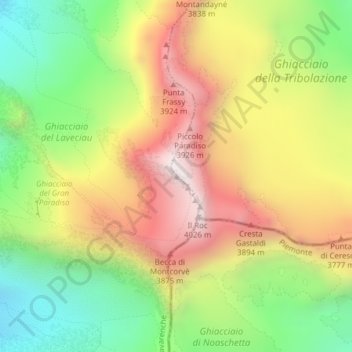
Name: Topografische Karte Gran Paradiso, Höhe, Relief.
Ort: Gran Paradiso, Valsavarenche, Aosta Valley, Italy (45.51777 7.26715 45.51787 7.26725)
Durchschnittliche Höhe: 3’459 m
Minimale Höhe: 2’950 m
Maximale Höhe: 4’019 m
The peak is the 7th highest mountain in the Graian Alps, with an elevation of 4,061 m. In the SOIUSA (International Standardized Mountain Subdivision of the Alps) the mountain belongs to an alpine subsection called "North-Eastern Graian Alps" (It:Alpi del Gran Paradiso; Fr:Alpes du Grand-Paradis) and also gives its name to the gruppo del Gran Paradiso.
Andere topografische Karten
Klicken Sie auf eine Karte, um ihre Topografie, ihre Höhe und ihr Relief anzuzeigen.
Le Pont
Italy > Aosta Valley > Valsavarenche
Le Pont, Valsavarenche, Aosta Valley, Italy
Durchschnittliche Höhe: 2’410 m