
Topografische Karte Belleville
Interaktive Karte
Klicken Sie auf die Karte, um die Höhe anzuzeigen.
Über diese Karte
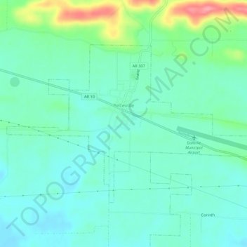
Name: Topografische Karte Belleville, Höhe, Relief.
Ort: Belleville, Yell County, Arkansas, 72824, United States (35.07562 -93.47331 35.10386 -93.41940)
Durchschnittliche Höhe: 120 m
Minimale Höhe: 97 m
Maximale Höhe: 191 m
Andere topografische Karten
Klicken Sie auf eine Karte, um ihre Topografie, ihre Höhe und ihr Relief anzuzeigen.
Petit Jean River State Wildlife Management Area
United States > Arkansas > Yell County
Petit Jean River State Wildlife Management Area, Yell County, Arkansas, 72829, United States
Durchschnittliche Höhe: 96 m
Rover
United States > Arkansas > Yell County
Rover, Yell County, Arkansas, 72860, United States
Durchschnittliche Höhe: 124 m
Mount Nebo
United States > Arkansas > Yell County
Mount Nebo, Yell County, Arkansas, United States
Durchschnittliche Höhe: 351 m
Dardanelle
United States > Arkansas > Yell County
Dardanelle, Yell County, Arkansas, 72834, United States
Durchschnittliche Höhe: 106 m
Ola
United States > Arkansas > Yell County > Ola > Ola
Ola, Yell County, Arkansas, 72853, United States
Durchschnittliche Höhe: 121 m
Petit Jean Mountain
United States > Arkansas > Yell County
Petit Jean Mountain, Yell County, Arkansas, United States
Durchschnittliche Höhe: 598 m