
Topografische Karte Prospect Creek
Interaktive Karte
Klicken Sie auf die Karte, um die Höhe anzuzeigen.
Über diese Karte
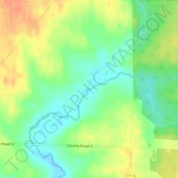
Name: Topografische Karte Prospect Creek, Höhe, Relief.
Durchschnittliche Höhe: 433 m
Minimale Höhe: 413 m
Maximale Höhe: 456 m
Andere topografische Karten
Klicken Sie auf eine Karte, um ihre Topografie, ihre Höhe und ihr Relief anzuzeigen.
City of Middleton
United States of America > Wisconsin > City of Middleton
City of Middleton, Dane County, Wisconsin, 53562, United States of America
Durchschnittliche Höhe: 290 m
Town of Albany
United States of America > Wisconsin
Town of Albany, Pepin County, Wisconsin, United States of America
Durchschnittliche Höhe: 298 m
Alderly Mill 1866c-71 Dam
United States of America > Wisconsin
Alderly Mill 1866c-71 Dam, Town of Ashippun, Dodge County, Wisconsin, United States of America
Durchschnittliche Höhe: 296 m
Big Bend
United States of America > Wisconsin > Big Bend
Big Bend, Waukesha County, Wisconsin, 53103, United States of America
Durchschnittliche Höhe: 268 m
Wills
United States of America > Wisconsin > Wills
Wills, Town of Hughes, Wisconsin, United States of America
Durchschnittliche Höhe: 359 m