
Spenden
Rüste dich für dein nächstes Abenteuer:
Als Amazon-Partner verdient diese Seite an qualifizierten Käufen, ohne dass Ihnen zusätzliche Kosten entstehen.
Topografische Karte Effingham
Klicken Sie auf die Karte, um die Höhe anzuzeigen.
Spenden
Rüste dich für dein nächstes Abenteuer:
Als Amazon-Partner verdient diese Seite an qualifizierten Käufen, ohne dass Ihnen zusätzliche Kosten entstehen.
Effingham
According to the United States Census Bureau, the town of Effingham has a total area of 39.9 square miles (103.4 km2), of which 38.8 square miles (100.4 km2) are land and 1.2 square miles (3.0 km2) are water, comprising 2.87% of the town. Green Mountain, elevation 1,884 feet (574 m), is the highest point in town. Effingham is drained by the Ossipee River and the Ossipee's tributaries, the Pine and South rivers. Province Lake lies partially within the town's borders to the south, and small portions of Ossipee Lake (Broad Bay and Berry Bay) are contained to the north. The community is bounded on the east by the Maine state line, and on the north by the Ossipee River. Effingham lies fully within the Saco River watershed. The Ossipee River subwatershed, partially in Effingham, is home to the largest stratified-drift aquifer in New Hampshire. Much of Effingham's land serves as aquifer recharge areas.
Spenden
Rüste dich für dein nächstes Abenteuer:
Als Amazon-Partner verdient diese Seite an qualifizierten Käufen, ohne dass Ihnen zusätzliche Kosten entstehen.
Über diese Karte
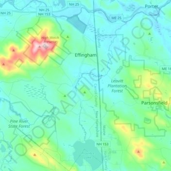
Name: Topografische Karte Effingham, Höhe, Relief.
Durchschnittliche Höhe: 188 m
Minimale Höhe: 110 m
Maximale Höhe: 571 m
Spenden
Rüste dich für dein nächstes Abenteuer:
Als Amazon-Partner verdient diese Seite an qualifizierten Käufen, ohne dass Ihnen zusätzliche Kosten entstehen.
Andere topografische Karten
Klicken Sie auf eine Karte, um ihre Topografie, ihre Höhe und ihr Relief anzuzeigen.
Center Sandwich
United States > New Hampshire > Carroll County > Sandwich
Durchschnittliche Höhe: 225 m
Castle in the Clouds
United States > New Hampshire > Carroll County > Moultonborough
Durchschnittliche Höhe: 363 m
Winnipesaukee
United States > New Hampshire > Carroll County > Moultonborough
Durchschnittliche Höhe: 161 m
Spenden
Rüste dich für dein nächstes Abenteuer:
Als Amazon-Partner verdient diese Seite an qualifizierten Käufen, ohne dass Ihnen zusätzliche Kosten entstehen.
Rogers Crossing
United States > New Hampshire > Carroll County > Bartlett
Durchschnittliche Höhe: 341 m
Spenden
Rüste dich für dein nächstes Abenteuer:
Als Amazon-Partner verdient diese Seite an qualifizierten Käufen, ohne dass Ihnen zusätzliche Kosten entstehen.
North Wakefield
United States > New Hampshire > Carroll County > Wakefield
Durchschnittliche Höhe: 220 m
Little Bear Island
United States > New Hampshire > Carroll County > Tuftonboro
Durchschnittliche Höhe: 160 m
Black Cat Island
United States > New Hampshire > Carroll County > Moultonborough
Durchschnittliche Höhe: 156 m
Nineacre Island
United States > New Hampshire > Carroll County > Moultonborough
Durchschnittliche Höhe: 158 m
Spenden
Rüste dich für dein nächstes Abenteuer:
Als Amazon-Partner verdient diese Seite an qualifizierten Käufen, ohne dass Ihnen zusätzliche Kosten entstehen.
Cranmore Mountain
United States > New Hampshire > Carroll County > Conway
Durchschnittliche Höhe: 373 m
Whortleberry Island
United States > New Hampshire > Carroll County > Tuftonboro > Chase Point
Durchschnittliche Höhe: 156 m
Cow Island
United States > New Hampshire > Carroll County > Tuftonboro > Fox Point
Durchschnittliche Höhe: 162 m
Wentworth Hill
United States > New Hampshire > Carroll County > Sandwich
Durchschnittliche Höhe: 209 m
Spenden
Rüste dich für dein nächstes Abenteuer:
Als Amazon-Partner verdient diese Seite an qualifizierten Käufen, ohne dass Ihnen zusätzliche Kosten entstehen.
Lees Mill
United States > New Hampshire > Carroll County > Moultonborough
Durchschnittliche Höhe: 173 m
Raccoon Mountain
United States > New Hampshire > Carroll County > Ossipee
Durchschnittliche Höhe: 220 m
Province Lake
United States > New Hampshire > Carroll County > Wakefield
Durchschnittliche Höhe: 159 m
Spenden
Rüste dich für dein nächstes Abenteuer:
Als Amazon-Partner verdient diese Seite an qualifizierten Käufen, ohne dass Ihnen zusätzliche Kosten entstehen.
South Tamworth
United States > New Hampshire > Carroll County > Tamworth
Durchschnittliche Höhe: 265 m
Mount Roberts
United States > New Hampshire > Carroll County > Moultonborough
Durchschnittliche Höhe: 611 m
Spenden
Rüste dich für dein nächstes Abenteuer:
Als Amazon-Partner verdient diese Seite an qualifizierten Käufen, ohne dass Ihnen zusätzliche Kosten entstehen.
Winnipesaukee
United States > New Hampshire > Carroll County > Moultonborough
Durchschnittliche Höhe: 161 m
Mirror Lake
United States > New Hampshire > Carroll County > Tuftonboro > Mirror Lake
Durchschnittliche Höhe: 169 m
South Tamworth
United States > New Hampshire > Carroll County > Tamworth
Durchschnittliche Höhe: 265 m
Whortleberry Island
United States > New Hampshire > Carroll County > Tuftonboro > Chase Point
Durchschnittliche Höhe: 156 m
Spenden
Rüste dich für dein nächstes Abenteuer:
Als Amazon-Partner verdient diese Seite an qualifizierten Käufen, ohne dass Ihnen zusätzliche Kosten entstehen.
Albany
United States > New Hampshire > Carroll County > Albany
According to the United States Census Bureau, the town has a total area of 75.8 square miles (196.2 km2), of which 75.1 square miles (194.6 km2) are land and 0.58 square miles (1.5 km2) are water, comprising 0.79% of the town. It is drained by the Swift River in the north and the Chocorua River in the south.…
Durchschnittliche Höhe: 276 m
Spenden
Rüste dich für dein nächstes Abenteuer:
Als Amazon-Partner verdient diese Seite an qualifizierten Käufen, ohne dass Ihnen zusätzliche Kosten entstehen.