
Spenden
Rüste dich für dein nächstes Abenteuer:
Als Amazon-Partner verdient diese Seite an qualifizierten Käufen, ohne dass Ihnen zusätzliche Kosten entstehen.
Topografische Karte Furley
Klicken Sie auf die Karte, um die Höhe anzuzeigen.
Spenden
Rüste dich für dein nächstes Abenteuer:
Als Amazon-Partner verdient diese Seite an qualifizierten Käufen, ohne dass Ihnen zusätzliche Kosten entstehen.
Über diese Karte
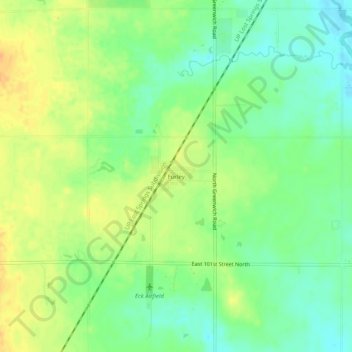
Name: Topografische Karte Furley, Höhe, Relief.
Ort: Furley, Sedgwick County, Kansas, United States (37.85918 -97.23282 37.89918 -97.19282)
Durchschnittliche Höhe: 426 m
Minimale Höhe: 410 m
Maximale Höhe: 443 m
Spenden
Rüste dich für dein nächstes Abenteuer:
Als Amazon-Partner verdient diese Seite an qualifizierten Käufen, ohne dass Ihnen zusätzliche Kosten entstehen.
Andere topografische Karten
Klicken Sie auf eine Karte, um ihre Topografie, ihre Höhe und ihr Relief anzuzeigen.
Wichita
United States > Kansas > Sedgwick County
Wichita features a predominantly flat and gently rolling landscape characteristic of the Great Plains region. The city sits at an elevation of approximately 1,300 feet above sea level and is crisscrossed by several small rivers, including the Arkansas River, which flows through the city, providing a slight…
Durchschnittliche Höhe: 408 m
Spenden
Rüste dich für dein nächstes Abenteuer:
Als Amazon-Partner verdient diese Seite an qualifizierten Käufen, ohne dass Ihnen zusätzliche Kosten entstehen.
Goddard
United States > Kansas > Sedgwick County
Goddard is located at 37°39′35″N 97°34′27″W / 37.65972°N 97.57417°W / 37.65972; -97.57417 (37.659706, -97.574271) at an elevation of 1,463 feet (446 m). Goddard lies on U.S. Route 54 in south-central Kansas, immediately west of Wichita.
Durchschnittliche Höhe: 443 m
Wichita
United States > Kansas > Sedgwick County
The city lies on the Arkansas River near the western edge of the Flint Hills in the Wellington-McPherson Lowlands region of the Great Plains. The area's topography is characterized by the broad alluvial plain of the Arkansas River valley and the moderately rolling slopes that rise to the higher lands on either…
Durchschnittliche Höhe: 408 m
Spenden
Rüste dich für dein nächstes Abenteuer:
Als Amazon-Partner verdient diese Seite an qualifizierten Käufen, ohne dass Ihnen zusätzliche Kosten entstehen.
Wichita
United States > Kansas > Sedgwick County
The city lies on the Arkansas River near the western edge of the Flint Hills in the Wellington-McPherson Lowlands region of the Great Plains. The area's topography is characterized by the broad alluvial plain of the Arkansas River valley and the moderately rolling slopes that rise to the higher lands on either…
Durchschnittliche Höhe: 408 m
Spenden
Rüste dich für dein nächstes Abenteuer:
Als Amazon-Partner verdient diese Seite an qualifizierten Käufen, ohne dass Ihnen zusätzliche Kosten entstehen.
Wichita
United States > Kansas > Sedgwick County
The city lies on the Arkansas River near the western edge of the Flint Hills in the Wellington-McPherson Lowlands region of the Great Plains. The area's topography is characterized by the broad alluvial plain of the Arkansas River valley and the moderately rolling slopes that rise to the higher lands on either…
Durchschnittliche Höhe: 408 m
Wichita
United States > Kansas > Sedgwick County
The city lies on the Arkansas River near the western edge of the Flint Hills in the Wellington-McPherson Lowlands region of the Great Plains. The area's topography is characterized by the broad alluvial plain of the Arkansas River valley and the moderately rolling slopes that rise to the higher lands on either…
Durchschnittliche Höhe: 408 m
Spenden
Rüste dich für dein nächstes Abenteuer:
Als Amazon-Partner verdient diese Seite an qualifizierten Käufen, ohne dass Ihnen zusätzliche Kosten entstehen.
Spenden
Rüste dich für dein nächstes Abenteuer:
Als Amazon-Partner verdient diese Seite an qualifizierten Käufen, ohne dass Ihnen zusätzliche Kosten entstehen.