
Spenden
Rüste dich für dein nächstes Abenteuer:
Als Amazon-Partner verdient diese Seite an qualifizierten Käufen, ohne dass Ihnen zusätzliche Kosten entstehen.
Topografische Karte Newbury Park
Klicken Sie auf die Karte, um die Höhe anzuzeigen.
Spenden
Rüste dich für dein nächstes Abenteuer:
Als Amazon-Partner verdient diese Seite an qualifizierten Käufen, ohne dass Ihnen zusätzliche Kosten entstehen.
Newbury Park
Newbury Park can be described as a town, community, or section mostly within the Thousand Oaks city limits in addition to rural areas west of Thousand Oaks. Newbury Park is bordered by Lynn Road in the east and the Conejo Grade on the west. It borders the Santa Monica Mountains in the south, while Hill Canyon and the ridges of Conejo Canyons Open Space make up its northernmost area. It has an average elevation of 628 feet (191 m) above sea level, and is situated 12 miles (19 km) from the Pacific Ocean. Newbury Park is 42 miles (68 km) west of Los Angeles. It is situated in the southeastern corner of Ventura County, between the Santa Monica Mountains to the south, and protected nature areas such as Wildwood Regional Park to the north. Thousand Oaks proper is to the east and the city of Camarillo is down the Conejo Grade to the west. Newbury Park is made up of ZIP code 91320; however, certain post office boxes by Newbury Road use ZIP code 91319.
Spenden
Rüste dich für dein nächstes Abenteuer:
Als Amazon-Partner verdient diese Seite an qualifizierten Käufen, ohne dass Ihnen zusätzliche Kosten entstehen.
Über diese Karte
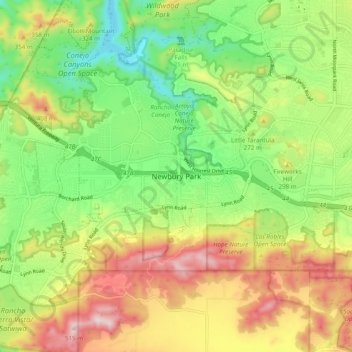
Name: Topografische Karte Newbury Park, Höhe, Relief.
Durchschnittliche Höhe: 262 m
Minimale Höhe: 76 m
Maximale Höhe: 509 m
Spenden
Rüste dich für dein nächstes Abenteuer:
Als Amazon-Partner verdient diese Seite an qualifizierten Käufen, ohne dass Ihnen zusätzliche Kosten entstehen.