
Topografische Karte Pine County
Interaktive Karte
Klicken Sie auf die Karte, um die Höhe anzuzeigen.
Über diese Karte
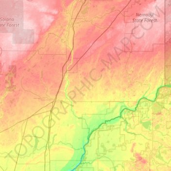
Name: Topografische Karte Pine County, Höhe, Relief.
Ort: Pine County, Minnesota, United States (45.73002 -93.14197 46.41842 -92.29278)
Durchschnittliche Höhe: 326 m
Minimale Höhe: 237 m
Maximale Höhe: 416 m
Andere topografische Karten
Klicken Sie auf eine Karte, um ihre Topografie, ihre Höhe und ihr Relief anzuzeigen.
Cloverton
United States > Minnesota > Pine County
Cloverton, New Dosey Township, Pine County, Minnesota, United States
Durchschnittliche Höhe: 332 m
Denham
United States > Minnesota > Pine County
Denham, Pine County, Minnesota, United States
Durchschnittliche Höhe: 375 m
Jarvis Bay
United States > Minnesota > Pine County
Jarvis Bay, Pine County, Minnesota, United States
Durchschnittliche Höhe: 286 m
Sandstone
United States > Minnesota > Pine County
Sandstone, Pine County, Minnesota, United States
Durchschnittliche Höhe: 332 m