
Topografische Karte Cameron
Interaktive Karte
Klicken Sie auf die Karte, um die Höhe anzuzeigen.
Cameron
Cameron is located in south-central Cameron Parish at 29°47′17″N 93°18′42″W / 29.78806°N 93.31167°W / 29.78806; -93.31167 (29.788055, -93.311764), along the Gulf of Mexico at an elevation of 4 feet (1.2 m) above sea level. State highways 27 and 82 pass through the community as Marshall Street, crossing the Calcasieu Ship Channel just west of town. Highway 82 leads east 93 miles (150 km) to Abbeville and west 48 miles (77 km) to Port Arthur, Texas. Highway 27 leads west then north 48 miles (77 km) to Sulphur. Lake Charles is 52 miles (84 km) to the north.
Über diese Karte
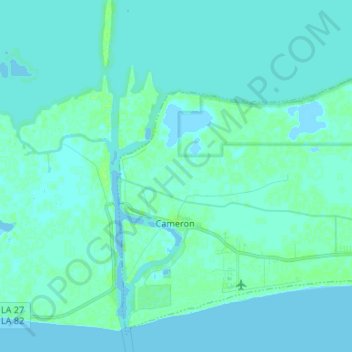
Name: Topografische Karte Cameron, Höhe, Relief.
Ort: Cameron, Cameron Parish, Louisiana, 70631, United States (29.76080 -93.34742 29.86469 -93.21477)
Durchschnittliche Höhe: 2 m
Minimale Höhe: -4 m
Maximale Höhe: 8 m
Andere topografische Karten
Klicken Sie auf eine Karte, um ihre Topografie, ihre Höhe und ihr Relief anzuzeigen.