
Topografische Karte Osage County
Interaktive Karte
Klicken Sie auf die Karte, um die Höhe anzuzeigen.
Über diese Karte
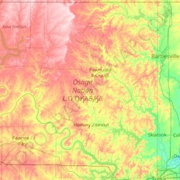
Name: Topografische Karte Osage County, Höhe, Relief.
Ort: Osage County, Oklahoma, United States (36.16079 -97.06701 36.99929 -96.00046)
Durchschnittliche Höhe: 277 m
Minimale Höhe: 175 m
Maximale Höhe: 413 m
Holmes Peak is a mountain northwest of Tulsa in Osage County. It was named by the United States Board on Geographic Names on October 5, 1983 for the fictional detective, Sherlock Holmes. The name was proposed by Richard S. Warner. Holmes Peak is the highest point in the Tulsa Metropolitan area, with an elevation of 1,030 feet (310 m), though it ranks only as the 379th highest point in the state.
Andere topografische Karten
Klicken Sie auf eine Karte, um ihre Topografie, ihre Höhe und ihr Relief anzuzeigen.
Skiatook
United States > Oklahoma > Osage County
Skiatook, Osage County, Oklahoma, 74070, United States
Durchschnittliche Höhe: 222 m
Foraker
United States > Oklahoma > Osage County
Foraker, Osage County, Oklahoma, United States
Durchschnittliche Höhe: 385 m
Fairfax
United States > Oklahoma > Osage County
Fairfax, Osage County, Oklahoma, United States
Durchschnittliche Höhe: 259 m
Herd
United States > Oklahoma > Osage County
Herd, Osage County, Oklahoma, United States
Durchschnittliche Höhe: 287 m