Geolokalisieren

Topografische Karte Bitahli Khad

Interaktive Karte

Klicken Sie auf die Karte, um die Höhe anzuzeigen.

Über diese Karte

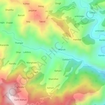
Name: Topografische Karte Bitahli Khad, Höhe, Relief.

Ort: Bitahli Khad, Karsog, Mandi, Himachal Pradesh, 175010, India (31.32078 77.19928 31.33601 77.24221)

Durchschnittliche Höhe: 1’431 m

Minimale Höhe: 1’072 m

Maximale Höhe: 1’926 m

Andere topografische Karten

Klicken Sie auf eine Karte, um ihre Topografie, ihre Höhe und ihr Relief anzuzeigen.

Bajandi

India > Himachal Pradesh > Karsog

Bajandi, Karsog, Mandi District, Himachal Pradesh, 175046, India

Durchschnittliche Höhe: 1’663 m

Sunni

India > Himachal Pradesh > Karsog

Sunni, Karsog, Mandi District, Himachal Pradesh, India

Durchschnittliche Höhe: 768 m

Tattapani

India > Himachal Pradesh > Karsog

Tattapani, Karsog, Mandi District, Himachal Pradesh, 175009, India

Durchschnittliche Höhe: 1’056 m

Nanj

India > Himachal Pradesh > Karsog

Nanj, Karsog, Mandi, Himachal Pradesh, 172027, India

Durchschnittliche Höhe: 1’156 m

Pangna

India > Himachal Pradesh > Karsog

Pangna, Karsog, Mandi, Himachal Pradesh, 175046, India

Durchschnittliche Höhe: 1’640 m

Churag

India > Himachal Pradesh > Karsog > Churag

Churag, Karsog, Mandi, Himachal Pradesh, 175010, India

Durchschnittliche Höhe: 1’760 m

Khanyar

India > Himachal Pradesh > Karsog

Khanyar, Karsog, Mandi, Himachal Pradesh, 175010, India

Durchschnittliche Höhe: 1’662 m