
Topografische Karte Garfield Heights
Interaktive Karte
Klicken Sie auf die Karte, um die Höhe anzuzeigen.
Über diese Karte
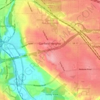
Name: Topografische Karte Garfield Heights, Höhe, Relief.
Durchschnittliche Höhe: 251 m
Minimale Höhe: 178 m
Maximale Höhe: 308 m
According to the United States Census Bureau, the city has a total area of 7.29 square miles (18.88 km2), of which 7.23 square miles (18.73 km2) is land and 0.06 square miles (0.16 km2) is water. The elevation of Garfield Heights is 831 feet (253 m) above sea level where it borders Cleveland, and its highest elevation is 972 feet (296 m) above sea level at the Garfield Heights Justice Center.