
Topografische Karte Towcester
Interaktive Karte
Klicken Sie auf die Karte, um die Höhe anzuzeigen.
Über diese Karte
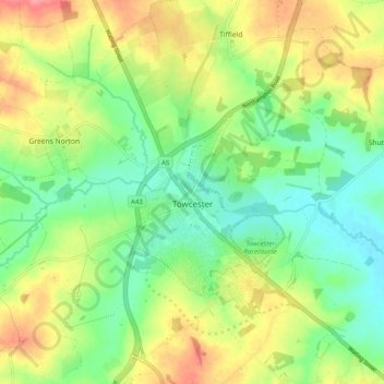
Name: Topografische Karte Towcester, Höhe, Relief.
Ort: Towcester, West Northamptonshire, England, United Kingdom (52.10412 -1.03535 52.16501 -0.95726)
Durchschnittliche Höhe: 111 m
Minimale Höhe: 78 m
Maximale Höhe: 158 m
St. Lawrence's C of E Church, stands in the middle of the town. It has a 12th-century Norman transitional ground plan and foundation, probably laid over a Saxon 10th century stone building. Its ecclesiastical heritage may well relate back to Roman times as St Lawrence was patron saint of the Roman legions. The building was reconstructed in the perpendicular style 1480–85 when the church tower was added. The tower contains 12 bells generally accepted by ringers across the country to be one of the finest sets in the Midlands. The bells were moved in 1994 from Todmorden in Yorkshire. Permission to quarry stone for this restoration from Whittlewood Forest was granted by Edward IV and later confirmed by Richard III on his way towards Leicestershire and his death at the Battle of Bosworth Field. The church contains a "Treacle" Bible, a table tomb and cadaver of Archdeacon Sponne, Rector 1422–1448. The Archdeacon started the second oldest grammar school in Northamptonshire but the oldest one in the United Kingdom, which was merged with the old secondary modern school in Towcester to produce Sponne School. It is also claimed that Pope Boniface VIII was a rector of the church before his elevation to the position of pope. The church tower contains a peal of 12 bells and a chime of 9 bells.
Andere topografische Karten
Klicken Sie auf eine Karte, um ihre Topografie, ihre Höhe und ihr Relief anzuzeigen.
Northampton
United Kingdom > England > West Northamptonshire > Northampton
Northampton, West Northamptonshire, England, United Kingdom
Durchschnittliche Höhe: 89 m
Middleton Cheney
United Kingdom > England > West Northamptonshire
Middleton Cheney, West Northamptonshire, England, United Kingdom
Durchschnittliche Höhe: 128 m
Blakesley
United Kingdom > England > West Northamptonshire
Blakesley, West Northamptonshire, England, United Kingdom
Durchschnittliche Höhe: 141 m
Daventry
United Kingdom > England > West Northamptonshire
Daventry, West Northamptonshire, England, United Kingdom
Durchschnittliche Höhe: 148 m
Chipping Warden
United Kingdom > England > West Northamptonshire
Chipping Warden, West Northamptonshire, England, OX17 1LA, United Kingdom
Durchschnittliche Höhe: 131 m
Brackley
United Kingdom > England > West Northamptonshire
Brackley, West Northamptonshire, England, United Kingdom
Durchschnittliche Höhe: 129 m
Kilsby
United Kingdom > England > West Northamptonshire
Kilsby, West Northamptonshire, England, United Kingdom
Durchschnittliche Höhe: 129 m