
Topografische Karte Horseshoe Bend National Military Park
Interaktive Karte
Klicken Sie auf die Karte, um die Höhe anzuzeigen.
Über diese Karte
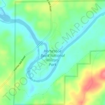
Name: Topografische Karte Horseshoe Bend National Military Park, Höhe, Relief.
Durchschnittliche Höhe: 186 m
Minimale Höhe: 160 m
Maximale Höhe: 238 m
Andere topografische Karten
Klicken Sie auf eine Karte, um ihre Topografie, ihre Höhe und ihr Relief anzuzeigen.
Alexander City
United States > Alabama > Tallapoosa County
Alexander City, Tallapoosa County, Alabama, 35010, United States
Durchschnittliche Höhe: 188 m
Camp Hill
United States > Alabama > Tallapoosa County > Camp Hill > Camp Hill
Camp Hill, Tallapoosa County, Alabama, 36850, United States
Durchschnittliche Höhe: 203 m