
Topografische Karte Pizzo Coca
Interaktive Karte
Klicken Sie auf die Karte, um die Höhe anzuzeigen.
Über diese Karte
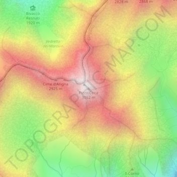
Name: Topografische Karte Pizzo Coca, Höhe, Relief.
Ort: Pizzo Coca, Valbondione, Bergamo, Lombardy, Italy (46.07147 10.01149 46.07157 10.01159)
Durchschnittliche Höhe: 2’380 m
Minimale Höhe: 1’652 m
Maximale Höhe: 3’042 m
The Alps are split into five climate zones, each with a different kind of environment. The climate, plant life and animal life vary on different sections or zones of the mountain such as Pizzo Coca. The initial altitude at Val Seriana, one of the recommended southern access points, is 1,100 meters and part of a valley. The valley trail rises to 1,892 meters by Rifugio Coca which is a rest stop.