
Spenden
Rüste dich für dein nächstes Abenteuer:
Als Amazon-Partner verdient diese Seite an qualifizierten Käufen, ohne dass Ihnen zusätzliche Kosten entstehen.
Topografische Karte Greenville
Klicken Sie auf die Karte, um die Höhe anzuzeigen.
Spenden
Rüste dich für dein nächstes Abenteuer:
Als Amazon-Partner verdient diese Seite an qualifizierten Käufen, ohne dass Ihnen zusätzliche Kosten entstehen.
Greenville
Greenville features a varied topography characterized by rolling hills and the nearby Blue Ridge Mountains. The city sits at an elevation of approximately 984 feet (300 meters) above sea level, with its landscape shaped significantly by the Reedy River, which flows through the heart of downtown, creating picturesque views and natural recreational areas. Surrounding Greenville, the terrain transitions into the mountainous regions to the north and east, offering scenic ridges and valleys that contribute to the area's biodiversity and unique microclimates. This mix of urban and natural environments not only enhances the aesthetic appeal but also provides numerous outdoor activities and scenic parks, making Greenville a vibrant place for residents and visitors alike.
Spenden
Rüste dich für dein nächstes Abenteuer:
Als Amazon-Partner verdient diese Seite an qualifizierten Käufen, ohne dass Ihnen zusätzliche Kosten entstehen.
Über diese Karte
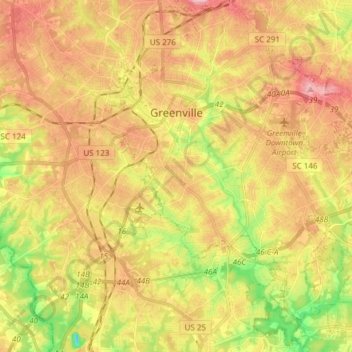
Name: Topografische Karte Greenville, Höhe, Relief.
Ort: Greenville, Greenville County, South Carolina, United States (34.76654 -82.43624 34.89260 -82.28689)
Durchschnittliche Höhe: 290 m
Minimale Höhe: 200 m
Maximale Höhe: 408 m
Spenden
Rüste dich für dein nächstes Abenteuer:
Als Amazon-Partner verdient diese Seite an qualifizierten Käufen, ohne dass Ihnen zusätzliche Kosten entstehen.
Andere topografische Karten
Klicken Sie auf eine Karte, um ihre Topografie, ihre Höhe und ihr Relief anzuzeigen.
Spenden
Rüste dich für dein nächstes Abenteuer:
Als Amazon-Partner verdient diese Seite an qualifizierten Käufen, ohne dass Ihnen zusätzliche Kosten entstehen.
Marietta
United States > South Carolina > Greenville County > Slater-Marietta
Durchschnittliche Höhe: 317 m
Caesars Head Mountain
United States > South Carolina > Greenville County
Durchschnittliche Höhe: 758 m
Alta Vista
United States > South Carolina > Greenville County > Greenville
Durchschnittliche Höhe: 286 m
Spenden
Rüste dich für dein nächstes Abenteuer:
Als Amazon-Partner verdient diese Seite an qualifizierten Käufen, ohne dass Ihnen zusätzliche Kosten entstehen.
Isaqueena Park
United States > South Carolina > Greenville County > Greenville
Durchschnittliche Höhe: 297 m
Fern Creek
United States > South Carolina > Greenville County > Conestee
Durchschnittliche Höhe: 260 m
Spenden
Rüste dich für dein nächstes Abenteuer:
Als Amazon-Partner verdient diese Seite an qualifizierten Käufen, ohne dass Ihnen zusätzliche Kosten entstehen.
North Hills
United States > South Carolina > Greenville County > Greenville
Durchschnittliche Höhe: 295 m
Cleveland Forest
United States > South Carolina > Greenville County > Greenville
Durchschnittliche Höhe: 287 m
Spenden
Rüste dich für dein nächstes Abenteuer:
Als Amazon-Partner verdient diese Seite an qualifizierten Käufen, ohne dass Ihnen zusätzliche Kosten entstehen.
Sherwood Forest
United States > South Carolina > Greenville County > Greenville
Durchschnittliche Höhe: 293 m
Little Table Rock Mountain
United States > South Carolina > Greenville County
Durchschnittliche Höhe: 892 m
Spenden
Rüste dich für dein nächstes Abenteuer:
Als Amazon-Partner verdient diese Seite an qualifizierten Käufen, ohne dass Ihnen zusätzliche Kosten entstehen.
Mount Vernon Estates
United States > South Carolina > Greenville County > Greer
Durchschnittliche Höhe: 302 m
Orchard Acres
United States > South Carolina > Greenville County > Wade Hampton
Durchschnittliche Höhe: 292 m
Piney Ridge
United States > South Carolina > Greenville County > Wade Hampton
Durchschnittliche Höhe: 304 m
Spenden
Rüste dich für dein nächstes Abenteuer:
Als Amazon-Partner verdient diese Seite an qualifizierten Käufen, ohne dass Ihnen zusätzliche Kosten entstehen.
White Horse
United States > South Carolina > Greenville County > Welcome
Durchschnittliche Höhe: 292 m
Crescentwood Village
United States > South Carolina > Greenville County > Mauldin
Durchschnittliche Höhe: 276 m
Spenden
Rüste dich für dein nächstes Abenteuer:
Als Amazon-Partner verdient diese Seite an qualifizierten Käufen, ohne dass Ihnen zusätzliche Kosten entstehen.
Summerwoods
United States > South Carolina > Greenville County > Mauldin
Durchschnittliche Höhe: 275 m
Morningside
United States > South Carolina > Greenville County > Wade Hampton
Durchschnittliche Höhe: 300 m
Evergreen Place
United States > South Carolina > Greenville County > Greenville
Durchschnittliche Höhe: 288 m
Spenden
Rüste dich für dein nächstes Abenteuer:
Als Amazon-Partner verdient diese Seite an qualifizierten Käufen, ohne dass Ihnen zusätzliche Kosten entstehen.
Boyce Lawn
United States > South Carolina > Greenville County > Greenville
Durchschnittliche Höhe: 290 m
Spenden
Rüste dich für dein nächstes Abenteuer:
Als Amazon-Partner verdient diese Seite an qualifizierten Käufen, ohne dass Ihnen zusätzliche Kosten entstehen.
Glenwood Acres
United States > South Carolina > Greenville County > Greenville
Durchschnittliche Höhe: 305 m
Stone Lake
United States > South Carolina > Greenville County > Greenville
Durchschnittliche Höhe: 305 m