Geolokalisieren

Topografische Karte Les Borels

Interaktive Karte

Klicken Sie auf die Karte, um die Höhe anzuzeigen.

Über diese Karte

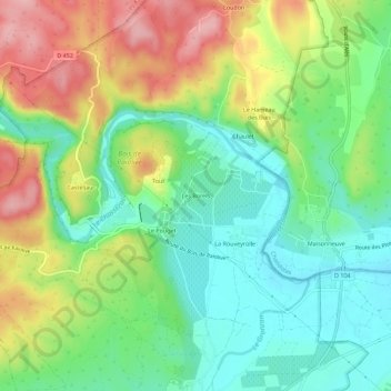
Name: Topografische Karte Les Borels, Höhe, Relief.

Ort: Les Borels, Casteljau, Berrias-et-Casteljau, Largentière, Ardèche, Auvergne-Rhône-Alpes, France métropolitaine, 07460, France (44.37933 4.19298 44.41933 4.23298)

Durchschnittliche Höhe: 164 m

Minimale Höhe: 105 m

Maximale Höhe: 255 m

Andere topografische Karten

Klicken Sie auf eine Karte, um ihre Topografie, ihre Höhe und ihr Relief anzuzeigen.

Mazet

France > Auvergne-Rhône-Alpes > Ardèche > Berrias-et-Casteljau

Mazet, Casteljau, Berrias-et-Casteljau, Largentière, Ardèche, Auvergne-Rhône-Alpes, France métropolitaine, 07460, France

Durchschnittliche Höhe: 171 m

Le Hameau des Buis

France > Auvergne-Rhône-Alpes > Ardèche > Berrias-et-Casteljau

Le Hameau des Buis, Casteljau, Berrias-et-Casteljau, Largentière, Ardèche, Auvergne-Rhône-Alpes, France métropolitaine, 07460, France

Durchschnittliche Höhe: 170 m

Grotte de la Tardive

France > Auvergne-Rhône-Alpes > Ardèche > Berrias-et-Casteljau > Casteljau

Grotte de la Tardive, La Presqu'Île, Casteljau, Berrias-et-Casteljau, Largentière, Ardèche, Auvergne-Rhône-Alpes, France métropolitaine, 07460, France

Durchschnittliche Höhe: 178 m

Le Pouget

France > Auvergne-Rhône-Alpes > Ardèche > Berrias-et-Casteljau

Le Pouget, Casteljau, Berrias-et-Casteljau, Largentière, Ardèche, Auvergne-Rhône-Alpes, France métropolitaine, 07460, France

Durchschnittliche Höhe: 162 m

Casteljau

France > Auvergne-Rhône-Alpes > Ardèche > Berrias-et-Casteljau

Casteljau, Berrias-et-Casteljau, Largentière, Ardèche, Auvergne-Rhône-Alpes, France métropolitaine, 07460, France

Durchschnittliche Höhe: 180 m

Berrias

France > Auvergne-Rhône-Alpes > Ardèche > Berrias-et-Casteljau

Berrias, Berrias-et-Casteljau, Largentière, Ardèche, Auvergne-Rhône-Alpes, France métropolitaine, 07460, France

Durchschnittliche Höhe: 174 m