
Topografische Karte Toronto Lake
Interaktive Karte
Klicken Sie auf die Karte, um die Höhe anzuzeigen.
Über diese Karte
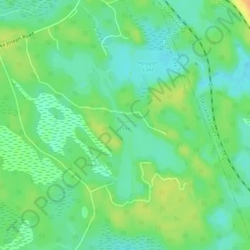
Name: Topografische Karte Toronto Lake, Höhe, Relief.
Durchschnittliche Höhe: 239 m
Minimale Höhe: 226 m
Maximale Höhe: 257 m
Andere topografische Karten
Klicken Sie auf eine Karte, um ihre Topografie, ihre Höhe und ihr Relief anzuzeigen.
Go Home Lake
Canada > Ontario > Georgian Bay Township
Go Home Lake, Lagoon Road, Georgian Bay Township, District Municipality of Muskoka, Muskoka District, Central Ontario, Ontario, Canada
Durchschnittliche Höhe: 192 m
Gloucester Pool
Canada > Ontario > Georgian Bay Township
Gloucester Pool, Rocky Shore Road, Georgian Bay Township, District Municipality of Muskoka, Muskoka District, Central Ontario, Ontario, L0K 1S0, Canada
Durchschnittliche Höhe: 186 m
Turtle Island
Canada > Ontario > Georgian Bay Township
Turtle Island, Georgian Bay Township, District Municipality of Muskoka, Muskoka District, Central Ontario, Ontario, Canada
Durchschnittliche Höhe: 194 m
Stewart Lake
Canada > Ontario > Georgian Bay Township
Stewart Lake, Stewart Lake Road, Georgian Bay Township, District Municipality of Muskoka, Muskoka District, Central Ontario, Ontario, Canada
Durchschnittliche Höhe: 241 m
Sweet Bay
Canada > Ontario > Georgian Bay Township
Sweet Bay, Georgian Bay Township, District Municipality of Muskoka, Muskoka District, Central Ontario, Ontario, L0K 1S0, Canada
Durchschnittliche Höhe: 185 m