
Topografische Karte Manns Peak
Interaktive Karte
Klicken Sie auf die Karte, um die Höhe anzuzeigen.
Über diese Karte
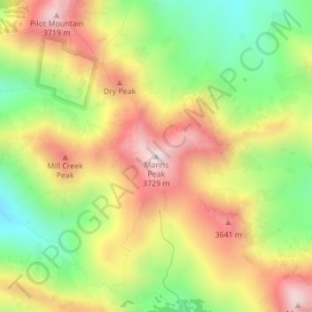
Name: Topografische Karte Manns Peak, Höhe, Relief.
Ort: Manns Peak, Grand County, Utah, United States (38.51497 -109.22257 38.51507 -109.22247)
Durchschnittliche Höhe: 3’427 m
Minimale Höhe: 3’123 m
Maximale Höhe: 3’739 m
Andere topografische Karten
Klicken Sie auf eine Karte, um ihre Topografie, ihre Höhe und ihr Relief anzuzeigen.
Moab
United States > Utah > Grand County
Moab, Grand County, Utah, 84532, United States
Durchschnittliche Höhe: 1’357 m
Castle Valley
United States > Utah > Grand County
Castle Valley, Grand County, Utah, United States
Durchschnittliche Höhe: 1’610 m
Castleton Tower
United States > Utah > Grand County
Castleton Tower, Grand County, Utah, United States
Durchschnittliche Höhe: 1’549 m
Arches National Park
United States > Utah > Grand County
Arches National Park, Grand County, Utah, United States
Durchschnittliche Höhe: 1’476 m