
Spenden
Rüste dich für dein nächstes Abenteuer:
Als Amazon-Partner verdient diese Seite an qualifizierten Käufen, ohne dass Ihnen zusätzliche Kosten entstehen.
Topografische Karte O'Neal Island
Klicken Sie auf die Karte, um die Höhe anzuzeigen.
Spenden
Rüste dich für dein nächstes Abenteuer:
Als Amazon-Partner verdient diese Seite an qualifizierten Käufen, ohne dass Ihnen zusätzliche Kosten entstehen.
Über diese Karte
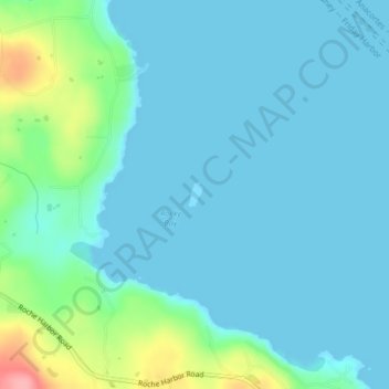
Name: Topografische Karte O'Neal Island, Höhe, Relief.
Ort: O'Neal Island, San Juan County, Washington, United States (48.60294 -123.09339 48.60468 -123.09181)
Durchschnittliche Höhe: 18 m
Minimale Höhe: 0 m
Maximale Höhe: 108 m
Spenden
Rüste dich für dein nächstes Abenteuer:
Als Amazon-Partner verdient diese Seite an qualifizierten Käufen, ohne dass Ihnen zusätzliche Kosten entstehen.
Andere topografische Karten
Klicken Sie auf eine Karte, um ihre Topografie, ihre Höhe und ihr Relief anzuzeigen.
Orcas Island
United States > Washington > San Juan County > Eastsound
Mount Constitution (elevation 2409 feet/734 meters) is the highest point in the San Juan islands. The mountain is part of Moran State Park, the largest public recreation area in the San Juan Islands, and the largest State Park in Washington. Moran State Park encompasses over 5,000 acres (2,000 ha) of woodland…
Durchschnittliche Höhe: 59 m
Lopez Island
United States > Washington > San Juan County > Lopez Village
Durchschnittliche Höhe: 21 m
San Juan Island
United States > Washington > San Juan County > Friday Harbor
Durchschnittliche Höhe: 26 m
Spenden
Rüste dich für dein nächstes Abenteuer:
Als Amazon-Partner verdient diese Seite an qualifizierten Käufen, ohne dass Ihnen zusätzliche Kosten entstehen.
Spenden
Rüste dich für dein nächstes Abenteuer:
Als Amazon-Partner verdient diese Seite an qualifizierten Käufen, ohne dass Ihnen zusätzliche Kosten entstehen.
Orcas Island
United States > Washington > San Juan County > Eastsound
Mount Constitution (elevation 2,409 feet (734 meters) is the highest point in the San Juan islands. The mountain is part of Moran State Park, the largest public recreation area in the San Juan Islands, and the largest State Park in Washington. Moran State Park encompasses over 5,000 acres (2,000 hectares) of…
Durchschnittliche Höhe: 59 m
San Juan Island
United States > Washington > San Juan County > Friday Harbor
Durchschnittliche Höhe: 26 m
Spenden
Rüste dich für dein nächstes Abenteuer:
Als Amazon-Partner verdient diese Seite an qualifizierten Käufen, ohne dass Ihnen zusätzliche Kosten entstehen.
Lopez Island
United States > Washington > San Juan County > Lopez Village
Durchschnittliche Höhe: 21 m
Spenden
Rüste dich für dein nächstes Abenteuer:
Als Amazon-Partner verdient diese Seite an qualifizierten Käufen, ohne dass Ihnen zusätzliche Kosten entstehen.
San Juan Island
United States > Washington > San Juan County > Friday Harbor
Durchschnittliche Höhe: 26 m
San Juan Islands National Wildlife Refuge
United States > Washington > San Juan County
Durchschnittliche Höhe: 24 m
Orcas Island
United States > Washington > San Juan County > Eastsound
Mount Constitution (elevation 2,409 feet (734 meters) is the highest point in the San Juan islands. The mountain is part of Moran State Park, the largest public recreation area in the San Juan Islands, and the largest State Park in Washington. Moran State Park encompasses over 5,000 acres (2,000 hectares) of…
Durchschnittliche Höhe: 59 m
Spenden
Rüste dich für dein nächstes Abenteuer:
Als Amazon-Partner verdient diese Seite an qualifizierten Käufen, ohne dass Ihnen zusätzliche Kosten entstehen.